
Carte topographique Salton Sea
Carte interactive
Cliquez sur la carte pour afficher l’altitude.
À propos de cette carte
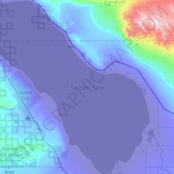
Nom : Carte topographique Salton Sea, altitude, relief.
Lieu : Salton Sea, Imperial County, California, United States (33.10833 -116.07614 33.52326 -115.60321)
Altitude moyenne : 9 m
Altitude minimum : -73 m
Altitude maximum : 897 m
The Gulf of California would extend as far north as the city of Indio, were it not for the delta created by the Colorado River. Over three million years, through all of the Pleistocene, the river's delta expanded until it cut off the northern part of the gulf. Since then, the Colorado River has alternated between emptying into the basin, creating a freshwater lake, and emptying into the gulf, leaving the lake to dry and turn to desert. Wave-cut shorelines at various elevations record a repeated cycle of filling and drying over hundreds of thousands of years. The most recent freshwater lake was Lake Cahuilla, also known as the Blake Sea after American professor and geologist William Phipps Blake. It covered over 2,000 square miles (5,200 km2), six times the area of the Salton Sea.
Autres cartes topographiques
Cliquez sur une carte pour visualiser sa topographie, son altitude et son relief.
Heber
United States > California > Imperial County
Heber, Imperial County, California, 92224, United States
Altitude moyenne : -3 m
Rico
United States > California > Imperial County
Rico, Imperial County, CAL Fire Southern Region, California, 92250, United States
Altitude moyenne : -7 m
Superstition Mountain
United States > California > Imperial County
Superstition Mountain, Imperial County, California, United States
Altitude moyenne : 130 m
Salton City
United States > California > Imperial County
Salton City, Imperial County, California, 92275, United States
Altitude moyenne : -35 m
Calipatria
United States > California > Imperial County
Calipatria, Imperial County, California, United States
Altitude moyenne : -50 m
Niland
United States > California > Imperial County > Niland
Niland, Imperial County, California, United States
Altitude moyenne : -40 m
Calipatria
United States > California > Imperial County > Calipatria
Calipatria, Imperial County, California, United States
Altitude moyenne : -53 m
Desert Shores
United States > California > Imperial County
Desert Shores, Imperial County, California, United States
Altitude moyenne : -58 m
El Centro
United States > California > Imperial County
El Centro, Imperial County, CAL Fire Southern Region, California, 92243, United States
Altitude moyenne : -10 m