
Carte topographique Salton City
Carte interactive
Cliquez sur la carte pour afficher l’altitude.
À propos de cette carte
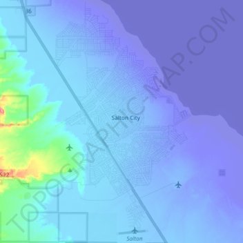
Nom : Carte topographique Salton City, altitude, relief.
Altitude moyenne : -35 m
Altitude minimum : -72 m
Altitude maximum : 88 m
In the 1970s, most of the buildings constructed along the shoreline, including the city's marina were abandoned due to rising sea elevation. In the 1980s, the Imperial Irrigation District took proactive water conservation measures to reduce the flow of unused canal water into the Salton Sea. Throughout the 1980s and 1990s, as salinity and suspected pollution levels in the Salton Sea increased, the attraction of the Salton Sea as a recreational destination diminished. Most of the original tourist related structures fell during this time, including the Truckhaven Cafe, the Salton Bay Yacht Club hotel and restaurant, and the Holly House motel and restaurant (later renamed Desser House and then the Sundowner).
Autres cartes topographiques
Cliquez sur une carte pour visualiser sa topographie, son altitude et son relief.
Heber
United States > California > Imperial County
Heber, Imperial County, California, 92224, United States
Altitude moyenne : -3 m
Rico
United States > California > Imperial County
Rico, Imperial County, CAL Fire Southern Region, California, 92250, United States
Altitude moyenne : -7 m
Salton Sea
United States > California > Imperial County
Salton Sea, Imperial County, California, United States
Altitude moyenne : 9 m
Superstition Mountain
United States > California > Imperial County
Superstition Mountain, Imperial County, California, United States
Altitude moyenne : 130 m
Calipatria
United States > California > Imperial County
Calipatria, Imperial County, California, United States
Altitude moyenne : -50 m
Niland
United States > California > Imperial County > Niland
Niland, Imperial County, California, United States
Altitude moyenne : -40 m
Calipatria
United States > California > Imperial County > Calipatria
Calipatria, Imperial County, California, United States
Altitude moyenne : -53 m
Desert Shores
United States > California > Imperial County
Desert Shores, Imperial County, California, United States
Altitude moyenne : -58 m
El Centro
United States > California > Imperial County
El Centro, Imperial County, CAL Fire Southern Region, California, 92243, United States
Altitude moyenne : -10 m