
Carte topographique Friedrichshöhe
Carte interactive
Cliquez sur la carte pour afficher l’altitude.
À propos de cette carte
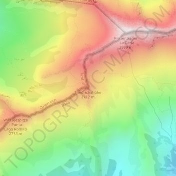
Nom : Carte topographique Friedrichshöhe, altitude, relief.
Altitude moyenne : 2 440 m
Altitude minimum : 1 931 m
Altitude maximum : 2 978 m
Autres cartes topographiques
Cliquez sur une carte pour visualiser sa topographie, son altitude et son relief.
St. Jakob
Italien > Trentino-Südtirol > Bozen > Pfitsch
St. Jakob, Pfitsch, Wipptal, Bozen, Trentino-Südtirol, Italien
Altitude moyenne : 1 809 m
Pfitsch
Italien > Trentino-Südtirol > Bozen > Pfitsch
Pfitsch, Wipptal, Bozen, Trentino-Südtirol, 39049, Italien
Altitude moyenne : 1 953 m
Kematen
Italien > Trentino-Südtirol > Bozen > Pfitsch
Kematen, Pfitsch, Wipptal, Bozen, Trentino-Südtirol, Italien
Altitude moyenne : 1 807 m