
Carte topographique Guangdong Province
Carte interactive
Cliquez sur la carte pour afficher l’altitude.
À propos de cette carte
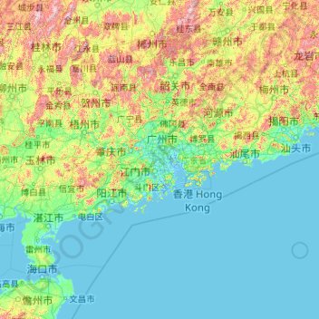
Nom : Carte topographique Guangdong Province, altitude, relief.
Lieu : Guangdong Province, China (20.11981 109.44948 25.51952 117.58023)
Altitude moyenne : 194 m
Altitude minimum : -5 m
Altitude maximum : 1 988 m
Guangdong faces the South China Sea to the south and has a total of 4,300 km (2,700 mi) of coastline. The Leizhou Peninsula is on the southwestern end of the province. There are a few inactive volcanoes on Leizhou Peninsula. The Pearl River Delta is the convergent point of three upstream rivers: the East River, North River, and West River. The river delta is filled with hundreds of small islands. The province is geographically separated from the north by a few mountain ranges collectively called the Nan Mountains (Nan Ling). The highest peak in the province is Shikengkong with an elevation of 6,240 feet (1,900 meters) above sea level.
Autres cartes topographiques
Cliquez sur une carte pour visualiser sa topographie, son altitude et son relief.
Shangbaishui
China > Yunnan > Yulong Nakhi Autonomous County > Daju
Shangbaishui, Daju, Yulong Nakhi Autonomous County, Lijiang City, Yunnan, China
Altitude moyenne : 2 990 m
Taiping District
Taiping District, Fuxin City, Liaoning, 123000, China
Altitude moyenne : 235 m
Tazhong
China > Xinjiang > Qarqan County > Tazhong Town
Tazhong, Tazhong Town, Qarqan County, Bayingolin, Xinjiang, China
Altitude moyenne : 1 116 m
Nam Bin Wai
China > Hong Kong > Yuen Long District > Tai Kiu Village
Nam Bin Wai, Tai Kiu Village, Yuen Long District, New Territories, Hong Kong, China
Altitude moyenne : 16 m
CN/VN disputes in Paracel Islands
CN/VN disputes in Paracel Islands, Hainan Province, 573199, China
Altitude moyenne : 0 m
Lion mountain
China > Zhejiang > Hangzhou City
Lion mountain, Hangzhou City, Zhejiang, 310024, China
Altitude moyenne : 15 m
Keriya County
Keriya County, Hotan Prefecture, Xinjiang, 848400, China
Altitude moyenne : 2 410 m
Yau Oi Chuen
China > Hong Kong > Sha Tin District > Tung Lo Wan
Yau Oi Chuen, Tung Lo Wan, Sha Tin District, New Territories, Hong Kong, China
Altitude moyenne : 156 m
Wuhua District
Wuhua District, Kunming, Yunnan, China
Altitude moyenne : 2 104 m
Daxingnanjiecun
China > Henan > Tangyin County
Daxingnanjiecun, Tangyin County, Anyang, Henan, China
Altitude moyenne : 85 m
Ap Lei Chau
China > Hong Kong > Hong Kong Island
Ap Lei Chau, Southern District, Hong Kong Island, Hong Kong, China
Altitude moyenne : 25 m
Yaha
China > Gansu > Zhugqu County > Wuping
Yaha, Wuping, Zhugqu County, Gannan, Gansu, 746300, China
Altitude moyenne : 2 174 m
Huancui District
Huancui District, Weihai, Shandong, 264200, China
Altitude moyenne : 41 m
Tai Mo Shan
China > Hong Kong > Tsuen Wan District
Tai Mo Shan, Tsuen Wan District, New Territories, Hong Kong, China
Altitude moyenne : 600 m
Yiwu County
Yiwu County, Hami, Yiwu, Xinjiang, China
Altitude moyenne : 1 215 m
Kaba
China > Xinjiang > Habahe County > 阿克齐镇
Kaba, 阿克齐镇, Habahe County, Altay Prefecture, Xinjiang, China
Altitude moyenne : 557 m