
Carte topographique Jiangsu
Carte interactive
Cliquez sur la carte pour afficher l’altitude.
À propos de cette carte
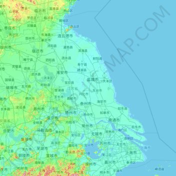
Nom : Carte topographique Jiangsu, altitude, relief.
Lieu : Jiangsu, China (30.76033 116.35520 35.16667 122.38666)
Altitude moyenne : 24 m
Altitude minimum : -3 m
Altitude maximum : 1 144 m
Jiangsu is flat, with plains covering 68 percent of its total area (water covers another 18 percent). Most of the province stands not more than 50 meters (160 ft) above sea level. Jiangsu also has a well-developed irrigation system, which earned it (especially the southern half) the moniker of traditional Chinese: 水鄕; simplified Chinese: 水乡 (shuǐxiāng "land of water"). The southern city of Suzhou has so many canals that it has been dubbed "Venice of the East" or the "Venice of the Orient." The Grand Canal of China cuts through Jiangsu from north to south, crossing all the east–west river systems. Jiangsu also borders the Yellow Sea. The Yangtze River, the longest river of China, cuts through the province in the south and reaches the East China Sea, which divides the region into two parts: more urban, prosperous south and more poorer, rural north, and these two parts has a tense division. Mount Huaguo, near the city of Lianyungang, is the highest point in Jiangsu, at an altitude of 625 meters (2,051 ft) above sea level. Large lakes in Jiangsu include Lake Tai (the largest), Lake Hongze, Lake Gaoyou, Lake Luoma, and Lake Yangcheng.
Autres cartes topographiques
Cliquez sur une carte pour visualiser sa topographie, son altitude et son relief.
Taiping District
Taiping District, Fuxin City, Liaoning, 123000, China
Altitude moyenne : 235 m
Tazhong
China > Xinjiang > Qarqan County > Tazhong Town
Tazhong, Tazhong Town, Qarqan County, Bayingolin, Xinjiang, China
Altitude moyenne : 1 116 m
Nam Bin Wai
China > Hong Kong > Yuen Long District > Tai Kiu Village
Nam Bin Wai, Tai Kiu Village, Yuen Long District, New Territories, Hong Kong, China
Altitude moyenne : 16 m
CN/VN disputes in Paracel Islands
CN/VN disputes in Paracel Islands, Hainan Province, 573199, China
Altitude moyenne : 0 m
Lion mountain
China > Zhejiang > Hangzhou City
Lion mountain, Hangzhou City, Zhejiang, 310024, China
Altitude moyenne : 15 m
Keriya County
Keriya County, Hotan Prefecture, Xinjiang, 848400, China
Altitude moyenne : 2 410 m
Yau Oi Chuen
China > Hong Kong > Sha Tin District > Tung Lo Wan
Yau Oi Chuen, Tung Lo Wan, Sha Tin District, New Territories, Hong Kong, China
Altitude moyenne : 156 m
Wuhua District
Wuhua District, Kunming, Yunnan, China
Altitude moyenne : 2 104 m
Daxingnanjiecun
China > Henan > Tangyin County
Daxingnanjiecun, Tangyin County, Anyang, Henan, China
Altitude moyenne : 85 m
Ap Lei Chau
China > Hong Kong > Hong Kong Island
Ap Lei Chau, Southern District, Hong Kong Island, Hong Kong, China
Altitude moyenne : 25 m
Yaha
China > Gansu > Zhugqu County > Wuping
Yaha, Wuping, Zhugqu County, Gannan, Gansu, 746300, China
Altitude moyenne : 2 174 m
Huancui District
Huancui District, Weihai, Shandong, 264200, China
Altitude moyenne : 41 m
Tai Mo Shan
China > Hong Kong > Tsuen Wan District
Tai Mo Shan, Tsuen Wan District, New Territories, Hong Kong, China
Altitude moyenne : 600 m
Yiwu County
Yiwu County, Hami, Yiwu, Xinjiang, China
Altitude moyenne : 1 215 m
Kaba
China > Xinjiang > Habahe County > 阿克齐镇
Kaba, 阿克齐镇, Habahe County, Altay Prefecture, Xinjiang, China
Altitude moyenne : 557 m