
Carte topographique St. Gallen
Carte interactive
Cliquez sur la carte pour afficher l’altitude.
À propos de cette carte
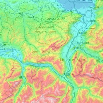
Nom : Carte topographique St. Gallen, altitude, relief.
Lieu : St. Gallen, Switzerland (46.87289 8.79561 47.54721 9.67414)
Altitude moyenne : 1 070 m
Altitude minimum : 392 m
Altitude maximum : 3 162 m
The main rivers of the canton are the Rhine, Thur, Linth and Seez. The topography changes from the plains, near river Rhine and Lake Constance, towards the mountainous areas of the Alps in the south (Appenzell Alps and Glarus Alps). About one third (619.7 square kilometers (239.3 sq mi)) of the canton is wooded, while nearly half is 9,790.6 km2 (3,780.2 sq mi) is used for farming. 278.6 km2 (107.6 sq mi) of the farm land is alpine pastures. Of the rest of the canton, 259.1 km2 (100.0 sq mi) is considered unproductive while 176 km2 (68 sq mi) is filled with housing or roads.
Autres cartes topographiques
Cliquez sur une carte pour visualiser sa topographie, son altitude et son relief.
Nendaz
Switzerland > Wallis > Conthey
Nendaz, Conthey, Wallis, 1997, Switzerland
Altitude moyenne : 1 771 m
Saas-Fee
Switzerland > Wallis > Visp
Saas-Fee, Visp, Wallis, 3906, Switzerland
Altitude moyenne : 2 673 m
Crans-Montana
Switzerland > Wallis > Sierre
Crans-Montana, Sierre, Wallis, 3960, Switzerland
Altitude moyenne : 1 660 m
Kiental
Switzerland > Bern > Frutigen-Niedersimmental administrative district > Reichenbach im Kandertal
Kiental, Reichenbach im Kandertal, Frutigen-Niedersimmental administrative district, Oberland administrative region, Bern, 3723, Switzerland
Altitude moyenne : 1 363 m
Schloss Wittigkofen
Switzerland > Bern > Bern-Mittelland administrative district > Bern > Schloss Wittigkofen
Schloss Wittigkofen, Wittigkofenweg, Wittigkofen, Murifeld, Schloss Wittigkofen, Stadtteil IV, Bern, Bern-Mittelland administrative district, Bernese Mittelland administrative region, Bern, 3006, Switzerland
Altitude moyenne : 568 m
Lausanne
Switzerland > Vaud > District de Lausanne
Lausanne, District de Lausanne, Vaud, Switzerland
Altitude moyenne : 621 m
Zermatt
Switzerland > Wallis > Visp
Zermatt, Visp, Wallis, 3920, Switzerland
Altitude moyenne : 2 921 m
Zernez
Switzerland > Grisons > Zernez
Zernez, Region Engiadina Bassa/Val Müstair, Grisons, 7530, Switzerland
Altitude moyenne : 2 297 m
Zurich
Switzerland > Zurich > District Zurich
Zurich, District Zurich, Zurich, Switzerland
Altitude moyenne : 499 m
Salvan
Switzerland > Valais/Wallis > Salvan
Salvan, Saint-Maurice, Valais/Wallis, Switzerland
Altitude moyenne : 1 350 m
Andermatt
Switzerland > Uri > Andermatt
Andermatt, Korporation Ursern, Uri, 6490, Switzerland
Altitude moyenne : 2 127 m
Saint-Gingolph
Switzerland > Valais/Wallis > Saint-Gingolph
Saint-Gingolph, Monthey, Valais/Wallis, 1898, Switzerland
Altitude moyenne : 1 171 m
Renges
Switzerland > Vaud > Ecublens > Renges
Renges, Ecublens, District de l'Ouest lausannois, Vaud, 1024, Switzerland
Altitude moyenne : 402 m
Hinterrhein
Hinterrhein, Viamala, Grisons, 7435, Switzerland
Altitude moyenne : 1 781 m
Wald (ZH)
Switzerland > Zurich > Wald (ZH)
Wald (ZH), Bezirk Hinwil, Zurich, Switzerland
Altitude moyenne : 798 m
Wünnewil-Flamatt
Switzerland > Fribourg > Wünnewil-Flamatt
Wünnewil-Flamatt, Sensebezirk, Fribourg, Switzerland
Altitude moyenne : 622 m
Disentis/Mustér
Switzerland > Grisons > Disentis/Mustér
Disentis/Mustér, Surselva, Grisons, 7180, Switzerland
Altitude moyenne : 2 068 m
Martigny
Switzerland > Valais/Wallis > Martigny
Martigny, Valais/Wallis, Switzerland
Altitude moyenne : 829 m
La Heutte
Switzerland > Bern > La Heutte
La Heutte, Arrondissement administratif du Jura bernois, Bern, 2604, Switzerland
Altitude moyenne : 892 m
Glarus Süd
Switzerland > Glarus > Glarus Süd
Glarus Süd, Glarus, Switzerland
Altitude moyenne : 1 835 m
Montreux
Switzerland > Vaud > Montreux
Montreux, District de la Riviera-Pays-d’Enhaut, Vaud, Switzerland
Altitude moyenne : 820 m
Lenk
Switzerland > Bern > Lenk
Lenk, Verwaltungskreis Obersimmental-Saanen, Verwaltungsregion Oberland, Bern, 3775, Switzerland
Altitude moyenne : 1 931 m
Islas
Switzerland > Grisons > Zuoz
Islas, Zuoz, Maloja, Grisons, 7524, Switzerland
Altitude moyenne : 1 812 m
Sous-les-Perrolets
Switzerland > Neuchâtel > Neuchâtel
Sous-les-Perrolets, Sous les perrolets, Pré Louiset, Neuchâtel, District de Neuchâtel, Neuchâtel, 2000, Switzerland
Altitude moyenne : 603 m
La Riondaz
Switzerland > Vaud > Leysin
La Riondaz, Leysin, District d'Aigle, Vaud, 1854, Switzerland
Altitude moyenne : 1 562 m
Rolle
Switzerland > Vaud > Rolle
Rolle, District de Nyon, Vaud, 1180, Switzerland
Altitude moyenne : 394 m
Charmey
Switzerland > Fribourg > Val-de-Charmey
Charmey, Val-de-Charmey, Gruyère District, Fribourg, 1637, Switzerland
Altitude moyenne : 1 299 m
Vaux
Switzerland > Vaud > Vaux
Vaux, District de Morges, Vaud, 1126, Switzerland
Altitude moyenne : 509 m
Collonge-Bellerive
Switzerland > Geneva > Collonge-Bellerive
Collonge-Bellerive, Geneva, Switzerland
Altitude moyenne : 403 m
Strahlhorn
Switzerland > Valais/Wallis > Saas-Almagell
Strahlhorn, Saas-Almagell, Visp, Valais/Wallis, 3905, Switzerland
Altitude moyenne : 3 581 m
Visp
Switzerland > Valais/Wallis > Visp
Visp, Valais/Wallis, 3930, Switzerland
Altitude moyenne : 1 195 m
Säntis
Switzerland > Appenzell Innerrhoden > Schwende
Säntis, Schwende, Appenzell Innerrhoden, 9057, Switzerland
Altitude moyenne : 1 938 m
Allalinhorn
Switzerland > Valais/Wallis > Saas-Fee
Allalinhorn, Saas-Fee, Visp, Valais/Wallis, 3906, Switzerland
Altitude moyenne : 3 490 m
Pennine Alps
Switzerland > Valais/Wallis > Zermatt
Pennine Alps, Zermatt, Visp, Valais/Wallis, 3920, Switzerland
Altitude moyenne : 3 842 m
Nyon
Switzerland > Vaud > District de Nyon > Nyon
Nyon, Grand Genève, District de Nyon, Vaud, 1260, Switzerland
Altitude moyenne : 404 m
Theodulgletscher
Switzerland > Valais/Wallis > Zermatt
Theodulgletscher, Klein Matterhorn, Trockener Steg, Zermatt, Visp, Valais/Wallis, 3920, Switzerland
Altitude moyenne : 3 228 m
Haut Glacier d'Arolla
Switzerland > Valais/Wallis > Evolène
Haut Glacier d'Arolla, Evolène, Hérens, Valais/Wallis, 1983, Switzerland
Altitude moyenne : 3 068 m
Nesthorn
Switzerland > Valais/Wallis > Naters
Nesthorn, Naters, Brig, Valais/Wallis, Switzerland
Altitude moyenne : 3 137 m
Wetterhorn
Switzerland > Bern > Grindelwald
Wetterhorn, Grindelwald, Verwaltungskreis Interlaken-Oberhasli, Verwaltungsregion Oberland, Bern, Switzerland
Altitude moyenne : 2 864 m
Eiger
Switzerland > Bern > Lauterbrunnen
Eiger, Lauterbrunnen, Verwaltungskreis Interlaken-Oberhasli, Verwaltungsregion Oberland, Bern, 3801, Switzerland
Altitude moyenne : 2 940 m