
Carte topographique Mount Olympus
Carte interactive
Cliquez sur la carte pour afficher l’altitude.
À propos de cette carte
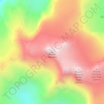
Nom : Carte topographique Mount Olympus, altitude, relief.
Lieu : Mount Olympus, Jefferson County, Washington, United States (47.80117 -123.71096 47.80127 -123.71086)
Altitude moyenne : 1 934 m
Altitude minimum : 1 337 m
Altitude maximum : 2 396 m
With notable local relief, Mount Olympus ascends over 2,100 m (6,900 ft) from the 293 m (961 ft) elevation confluence of the Hoh River with Glacier Creek in only 8.8 km (5.5 mi). Mount Olympus has 2,386 m (7,828 ft) of prominence, ranking 5th in the state of Washington.
Autres cartes topographiques
Cliquez sur une carte pour visualiser sa topographie, son altitude et son relief.
Port Townsend
United States > Washington > Jefferson County
Port Townsend, Jefferson County, Washington, United States
Altitude moyenne : 19 m
Olympic National Park
United States > Washington > Jefferson County
Olympic National Park, Jefferson County, Washington, United States
Altitude moyenne : 412 m
Quimper Peninsula
United States > Washington > Jefferson County
Quimper Peninsula, Jefferson County, Washington, 98368, United States
Altitude moyenne : 69 m
Queets
United States > Washington > Jefferson County
Queets, Jefferson County, Washington, United States
Altitude moyenne : 36 m
Marrowstone
United States > Washington > Jefferson County > Marrowstone
Marrowstone, Jefferson County, Washington, 98358, United States
Altitude moyenne : 11 m
Admiralty Inlet
United States > Washington > Jefferson County > Port Townsend
Admiralty Inlet, Port Townsend, Jefferson County, Washington, United States
Altitude moyenne : 34 m
Chimacum
United States > Washington > Jefferson County
Chimacum, Jefferson County, Washington, 98339, United States
Altitude moyenne : 59 m
Port Ludlow
United States > Washington > Jefferson County > Port Ludlow
Port Ludlow, Jefferson County, Washington, 98365, United States
Altitude moyenne : 64 m
Upper Hoh
United States > Washington > Jefferson County
Upper Hoh, Jefferson County, Washington, United States
Altitude moyenne : 161 m
Port Hadlock
United States > Washington > Jefferson County
Port Hadlock, Jefferson County, Washington, 98339, United States
Altitude moyenne : 31 m
Lackawanna Beach
United States > Washington > Jefferson County
Lackawanna Beach, Jefferson County, Washington, 98320, United States
Altitude moyenne : 18 m
Brinnon
United States > Washington > Jefferson County
Brinnon, Jefferson County, Washington, 98320, United States
Altitude moyenne : 204 m
Port Townsend
United States > Washington > Jefferson County > Port Townsend
Port Townsend, Jefferson County, Washington, United States
Altitude moyenne : 31 m
Port Townsend
United States > Washington > Jefferson County > Port Townsend > Port Townsend
Port Townsend, Jefferson County, Washington, United States
Altitude moyenne : 18 m
Mount Townsend
United States > Washington > Jefferson County
Mount Townsend, Jefferson County, Washington, United States
Altitude moyenne : 1 518 m
Nordland
United States > Washington > Jefferson County > Nordland
Nordland, Jefferson County, Washington, 98339, United States
Altitude moyenne : 11 m
Quilcene
United States > Washington > Jefferson County
Quilcene, Jefferson County, Washington, United States
Altitude moyenne : 116 m
Tukey
United States > Washington > Jefferson County
Tukey, Jefferson County, Washington, United States
Altitude moyenne : 34 m