
Carte topographique Olympic National Park
Carte interactive
Cliquez sur la carte pour afficher l’altitude.
À propos de cette carte
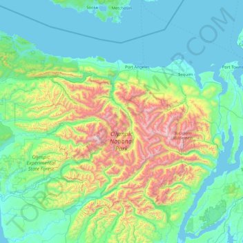
Nom : Carte topographique Olympic National Park, altitude, relief.
Altitude moyenne : 412 m
Altitude minimum : -3 m
Altitude maximum : 2 367 m
Views of the Olympic National Park can be seen from the Hurricane Ridge viewpoint. The road leading west from the Hurricane Ridge visitor center has several picnic areas and trailheads. A paved trail called the Hurricane Hill trail is about 1.6 miles (2.6 km) long each way, with an elevation gain of about 700 feet (210 m). It is not uncommon to find snow on the trails even as late as July. Several other dirt trails of varying distances and difficulty levels branch off of the Hurricane hill trail. The picnic areas are open only in the summer and have restrooms, water, and paved access to picnic tables.
Autres cartes topographiques
Cliquez sur une carte pour visualiser sa topographie, son altitude et son relief.
Port Townsend
United States > Washington > Jefferson County
Port Townsend, Jefferson County, Washington, United States
Altitude moyenne : 19 m
Quimper Peninsula
United States > Washington > Jefferson County
Quimper Peninsula, Jefferson County, Washington, 98368, United States
Altitude moyenne : 69 m
Queets
United States > Washington > Jefferson County
Queets, Jefferson County, Washington, United States
Altitude moyenne : 36 m
Marrowstone
United States > Washington > Jefferson County > Marrowstone
Marrowstone, Jefferson County, Washington, 98358, United States
Altitude moyenne : 11 m
Admiralty Inlet
United States > Washington > Jefferson County > Port Townsend
Admiralty Inlet, Port Townsend, Jefferson County, Washington, United States
Altitude moyenne : 34 m
Chimacum
United States > Washington > Jefferson County
Chimacum, Jefferson County, Washington, 98339, United States
Altitude moyenne : 59 m
Port Ludlow
United States > Washington > Jefferson County > Port Ludlow
Port Ludlow, Jefferson County, Washington, 98365, United States
Altitude moyenne : 64 m
Upper Hoh
United States > Washington > Jefferson County
Upper Hoh, Jefferson County, Washington, United States
Altitude moyenne : 161 m
Port Hadlock
United States > Washington > Jefferson County
Port Hadlock, Jefferson County, Washington, 98339, United States
Altitude moyenne : 31 m
Lackawanna Beach
United States > Washington > Jefferson County
Lackawanna Beach, Jefferson County, Washington, 98320, United States
Altitude moyenne : 18 m
Brinnon
United States > Washington > Jefferson County
Brinnon, Jefferson County, Washington, 98320, United States
Altitude moyenne : 204 m
Port Townsend
United States > Washington > Jefferson County > Port Townsend
Port Townsend, Jefferson County, Washington, United States
Altitude moyenne : 31 m
Port Townsend
United States > Washington > Jefferson County > Port Townsend > Port Townsend
Port Townsend, Jefferson County, Washington, United States
Altitude moyenne : 18 m
Mount Townsend
United States > Washington > Jefferson County
Mount Townsend, Jefferson County, Washington, United States
Altitude moyenne : 1 518 m
Nordland
United States > Washington > Jefferson County > Nordland
Nordland, Jefferson County, Washington, 98339, United States
Altitude moyenne : 11 m
Mount Olympus
United States > Washington > Jefferson County
Mount Olympus, Jefferson County, Washington, United States
Altitude moyenne : 1 934 m
Quilcene
United States > Washington > Jefferson County
Quilcene, Jefferson County, Washington, United States
Altitude moyenne : 116 m
Tukey
United States > Washington > Jefferson County
Tukey, Jefferson County, Washington, United States
Altitude moyenne : 34 m