
Carte topographique Dodge County
Carte interactive
Cliquez sur la carte pour afficher l’altitude.
À propos de cette carte
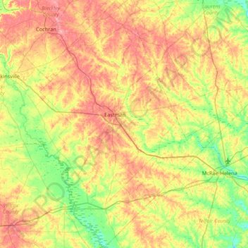
Nom : Carte topographique Dodge County, altitude, relief.
Lieu : Dodge County, Georgia, United States (31.90071 -83.37412 32.45243 -82.85804)
Altitude moyenne : 84 m
Altitude minimum : 40 m
Altitude maximum : 141 m
The Heart of Georgia Regional Airport is located three miles east of Eastman off of State Route 46. Elevation 304'. Runway 02/20 is 6,506'x100'and has a precision instrument landing system. The airport is owned by the Heart of Georgia Regional Airport Authority and is home to the Middle Georgia State College Georgia Aviation campus. Middle Georgia State College operates the Federal Aviation Administration's #1 ranked student control tower in the United States. Other businesses at the airport include aircraft manufacturing, aircraft metal finishing, and general metal fabrication. The airport's fixed-base operator is located in the terminal building midfield. The terminal building is named after W. S. Stuckey Sr., founder of Stuckey's Candy Company (now Standard Candy) an aviation pioneer who is from Eastman.
Autres cartes topographiques
Cliquez sur une carte pour visualiser sa topographie, son altitude et son relief.
Toccoa
United States > Georgia > Stephens County
Toccoa, Stephens County, Georgia, 30577, United States
Altitude moyenne : 303 m
Chatham County
United States > Georgia > Chatham County
Chatham County, Georgia, United States
Altitude moyenne : 3 m
Spalding County
Spalding County, Georgia, United States
Altitude moyenne : 247 m
Bonaire
United States > Georgia > Houston County
Bonaire, Houston County, Georgia, 31005, United States
Altitude moyenne : 100 m
Helen
United States > Georgia > White County
Helen, White County, Georgia, 30545, United States
Altitude moyenne : 488 m
Booth Lake
United States > Georgia > Wilkes County > Washington > Ravenwood Park
Booth Lake, Ravenwood Park, Washington, Wilkes County, Georgia, United States
Altitude moyenne : 175 m
Fort Pulaski
United States > Georgia > Chatham County
Fort Pulaski, Fort Perimeter Trail, Chatham County, Georgia, 31328, United States
Altitude moyenne : 1 m
Griffin Lake
United States > Georgia > Brooks County
Griffin Lake, Brooks County, Georgia, United States
Altitude moyenne : 60 m
Rowland Lake
United States > Georgia > Jones County
Rowland Lake, Jones County, Georgia, United States
Altitude moyenne : 175 m
Ponder Park
United States > Georgia > Tift County > Omega
Ponder Park, Omega, Tift County, Georgia, United States
Altitude moyenne : 96 m
Hiawassee
United States > Georgia > Towns County
Hiawassee, Towns County, Georgia, United States
Altitude moyenne : 620 m
Powder Springs
United States > Georgia > Cobb County
Powder Springs, Cobb County, Georgia, United States
Altitude moyenne : 291 m
Brasstown Bald
United States > Georgia > Towns County
Brasstown Bald, Towns County, Georgia, United States
Altitude moyenne : 1 161 m
Adel
United States > Georgia > Cook County
Adel, Cook County, Georgia, 31620, United States
Altitude moyenne : 72 m
Cherokee Hills
United States > Georgia > Coffee County
Cherokee Hills, Coffee County, Georgia, United States
Altitude moyenne : 70 m
Lake City
United States > Georgia > Clayton County
Lake City, Clayton County, Georgia, United States
Altitude moyenne : 287 m
Whitfield County
Whitfield County, Georgia, United States
Altitude moyenne : 258 m
Forbes Lake
United States > Georgia > Macon County
Forbes Lake, Macon County, Georgia, United States
Altitude moyenne : 126 m
Leesburg
United States > Georgia > Lee County
Leesburg, Lee County, Georgia, United States
Altitude moyenne : 76 m
Snodgrass Hill
United States > Georgia > Walker County > Fort Oglethorpe
Snodgrass Hill, Fort Oglethorpe, Walker County, Georgia, 30741, United States
Altitude moyenne : 250 m
Moon River
United States > Georgia > Chatham County > Burnside View
Moon River, Burnside View, Chatham County, Georgia, 31411, United States
Altitude moyenne : 2 m
Rossville
United States > Georgia > Walker County
Rossville, Walker County, Georgia, United States
Altitude moyenne : 251 m
Lake Seminole
United States > Georgia > Seminole County > Chattahoochee
Lake Seminole, Chattahoochee, Seminole County, Georgia, United States
Altitude moyenne : 32 m
Baxley
United States > Georgia > Appling County
Baxley, Appling County, Georgia, 31515, United States
Altitude moyenne : 61 m
Bainbridge
United States > Georgia > Decatur County
Bainbridge, Decatur County, Georgia, United States
Altitude moyenne : 37 m
Shenandoah Woods
United States > Georgia > Columbia County
Shenandoah Woods, Columbia County, Georgia, 30907, United States
Altitude moyenne : 97 m
Hiram
United States > Georgia > Paulding County
Hiram, Paulding County, Georgia, United States
Altitude moyenne : 306 m
Roswell
United States > Georgia > Fulton County
Roswell, Fulton County, Georgia, United States
Altitude moyenne : 316 m
Lawrenceville
United States > Georgia > Gwinnett County
Lawrenceville, Gwinnett County, Georgia, United States
Altitude moyenne : 312 m
High Hill Lake
United States > Georgia > Glynn County
High Hill Lake, Glynn County, Georgia, 31525, United States
Altitude moyenne : 7 m
Newnan
United States > Georgia > Coweta County
Newnan, Coweta County, Georgia, 30263, United States
Altitude moyenne : 272 m
Crowe Lake
United States > Georgia > Gwinnett County
Crowe Lake, Gwinnett County, Georgia, United States
Altitude moyenne : 349 m
Tybee Island
United States > Georgia > Chatham County
Tybee Island, Chatham County, Georgia, 31328, United States
Altitude moyenne : 1 m
Johns Creek
United States > Georgia > Fulton County > Johns Creek
Johns Creek, Fulton County, Georgia, 30097, United States
Altitude moyenne : 305 m
Atlanta
United States > Georgia > Fulton County
Atlanta, Fulton County, Georgia, 30303, United States
Altitude moyenne : 285 m
Peachtree City
United States > Georgia > Fayette County
Peachtree City, Fayette County, Georgia, 30269, United States
Altitude moyenne : 263 m
Colquitt County
Colquitt County, Georgia, United States
Altitude moyenne : 85 m
Milton
United States > Georgia > Fulton County
Milton, Fulton County, Georgia, 30004, United States
Altitude moyenne : 330 m