
Carte topographique Elmore County
Carte interactive
Cliquez sur la carte pour afficher l’altitude.
À propos de cette carte
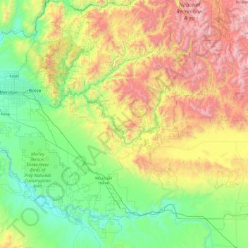
Nom : Carte topographique Elmore County, altitude, relief.
Lieu : Elmore County, Idaho, United States (42.76810 -116.26622 44.09869 -114.97136)
Altitude moyenne : 1 441 m
Altitude minimum : 701 m
Altitude maximum : 3 405 m
According to the U.S. Census Bureau, the county has a total area of 3,101 square miles (8,030 km2), of which 3,075 square miles (7,960 km2) is land and 26 square miles (67 km2) (0.8%) is water. Elmore County's highest point is Snowyside Peak at 10,651 feet (3,246 m) above sea level, located in the northeast corner of the county in the Sawtooth Wilderness. The lowest elevation in the county is the Snake River in the southwest corner, at less than 2,500 feet (760 m).
Autres cartes topographiques
Cliquez sur une carte pour visualiser sa topographie, son altitude et son relief.
Kuna
United States > Idaho > Ada County
Kuna, Ada County, Idaho, United States
Altitude moyenne : 830 m
Miller Water Table
United States > Idaho > Owyhee County
Miller Water Table, Owyhee County, Idaho, United States
Altitude moyenne : 1 140 m
Big Clear lake
United States > Idaho > Lemhi County
Big Clear lake, Lemhi County, Idaho, United States
Altitude moyenne : 2 617 m
Stanley
United States > Idaho > Custer County
Stanley, Custer County, Idaho, United States
Altitude moyenne : 1 931 m
Chief
United States > Idaho > Valley County
Chief, Valley County, Idaho, United States
Altitude moyenne : 2 249 m
Soda Springs
United States > Idaho > Caribou County
Soda Springs, Caribou County, Idaho, 83276, United States
Altitude moyenne : 1 783 m
Idaho Falls
United States > Idaho > Bonneville County
Idaho Falls, Bonneville County, Idaho, United States
Altitude moyenne : 1 441 m
Snake River
United States > Idaho > Washington County
Snake River, Washington County, Idaho, United States
Altitude moyenne : 643 m
Hagerman
United States > Idaho > Gooding County > Hagerman
Hagerman, Gooding County, Idaho, 83332, United States
Altitude moyenne : 900 m
Boise
United States > Idaho > Ada County
Boise, Ada County, Idaho, 83701, United States
Altitude moyenne : 1 040 m
K Mountain
United States > Idaho > Lemhi County
K Mountain, Lemhi County, Idaho, United States
Altitude moyenne : 2 120 m
Idaho Falls
United States > Idaho > Bonneville County > Idaho Falls
Idaho Falls, Bonneville County, Idaho, 83403, United States
Altitude moyenne : 1 512 m
McCall
United States > Idaho > Valley County > McCall
McCall, Valley County, Idaho, 83638, United States
Altitude moyenne : 1 546 m
Washington County
Washington County, Idaho, United States
Altitude moyenne : 1 122 m
Corkscrew Mountain
Corkscrew Mountain, Idaho, United States
Altitude moyenne : 2 459 m
Oneida County
United States > Idaho > Oneida County
Oneida County, Idaho, United States
Altitude moyenne : 1 678 m
Ruth Lake
Ruth Lake, Adams County, Idaho, United States
Altitude moyenne : 2 218 m
Newdale
United States > Idaho > Fremont County
Newdale, Fremont County, Idaho, 83436, United States
Altitude moyenne : 1 550 m
Sandpoint
United States > Idaho > Sandpoint
Sandpoint, Bonner County, Idaho, 83864, United States
Altitude moyenne : 658 m
Twin Falls County
Twin Falls County, Idaho, United States
Altitude moyenne : 1 404 m
Bear Lake County
Bear Lake County, Idaho, United States
Altitude moyenne : 2 095 m
Idaho City
United States > Idaho > Boise County
Idaho City, Boise County, Idaho, 83631, United States
Altitude moyenne : 1 236 m
Mud Lake
United States > Idaho > Jefferson County
Mud Lake, Jefferson County, Idaho, United States
Altitude moyenne : 1 460 m
Snake River
United States > Idaho > Washington County
Snake River, Washington County, Idaho, United States
Altitude moyenne : 643 m
Boise
United States > Idaho > Ada County
Boise, Ada County, Idaho, United States
Altitude moyenne : 974 m
Bonneville County
Bonneville County, Idaho, United States
Altitude moyenne : 1 963 m
Worley
United States > Idaho > Kootenai County
Worley, Kootenai County, Idaho, United States
Altitude moyenne : 830 m
Nampa
United States > Idaho > Canyon County > Nampa
Nampa, Canyon County, Idaho, United States
Altitude moyenne : 764 m
Grangeville
United States > Idaho > Idaho County
Grangeville, Idaho County, Idaho, United States
Altitude moyenne : 1 037 m
Snake River
United States > Idaho > Washington County
Snake River, Washington County, Idaho, 83672, United States
Altitude moyenne : 644 m