
Carte topographique Point Fortin
Carte interactive
Cliquez sur la carte pour afficher l’altitude.
À propos de cette carte
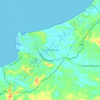
Nom : Carte topographique Point Fortin, altitude, relief.
Lieu : Point Fortin, Trinidad and Tobago (10.14100 -61.70764 10.20655 -61.63279)
Altitude moyenne : 9 m
Altitude minimum : -1 m
Altitude maximum : 45 m
Point Fortin, officially the Republic Borough of Point Fortin, the smallest Borough in Trinidad and Tobago is located in southwestern Trinidad, about 32 km (20 mi) southwest of San Fernando, in the historic county of Saint Patrick. After the discovery of petroleum in the area in 1906 the town grew into a major oil-producing centre. The town grew with the oil industry between the 1940s and 1980s, culminating in its elevation to borough status in 1980. After the end of the oil boom Point Fortin was hit hard by economic recession in the 1980s and the closure of its oil refinery. Construction of a Liquefied Natural Gas plant by Atlantic LNG in late 1990s boosted the economy.
Autres cartes topographiques
Cliquez sur une carte pour visualiser sa topographie, son altitude et son relief.
The Park at Haleland Park
Trinidad and Tobago > Diego Martin
The Park at Haleland Park, Diego Martin, Trinidad and Tobago
Altitude moyenne : 200 m
Las Cuevas
Trinidad and Tobago > San Juan-Laventille
Las Cuevas, San Juan-Laventille, Trinidad and Tobago
Altitude moyenne : 61 m
Trinidad
Trinidad and Tobago > Couva-Tabaquite-Talparo
Trinidad, Couva-Tabaquite-Talparo, Trinidad and Tobago
Altitude moyenne : 30 m
Brickfield
Trinidad and Tobago > Couva-Tabaquite-Talparo
Brickfield, Couva-Tabaquite-Talparo, Trinidad and Tobago
Altitude moyenne : 4 m
Point Cumana
Trinidad and Tobago > Diego Martin
Point Cumana, Diego Martin, 110712, Trinidad and Tobago
Altitude moyenne : 70 m
Augustus Williams Park
Trinidad and Tobago > Port of Spain
Augustus Williams Park, Woodbrook, Port of Spain, Trinidad and Tobago
Altitude moyenne : 14 m
Coryal
Trinidad and Tobago > Sangre Grande
Coryal, Sangre Grande, Trinidad and Tobago
Altitude moyenne : 57 m
Barrackpore
Trinidad and Tobago > Princes Town
Barrackpore, Princes Town, Trinidad and Tobago
Altitude moyenne : 19 m
Las Cuevas Bay
Trinidad and Tobago > San Juan-Laventille
Las Cuevas Bay, North Coast Road, San Juan-Laventille, Trinidad and Tobago
Altitude moyenne : 54 m
Tunapuna
Trinidad and Tobago > Tunapuna-Piarco
Tunapuna, Tunapuna-Piarco, 310407, Trinidad and Tobago
Altitude moyenne : 93 m
Vessigny Beach
Trinidad and Tobago > Siparia > Vessigny
Vessigny Beach, Vessigny, Siparia, Trinidad and Tobago
Altitude moyenne : 12 m
Rio Claro-Mayaro
Trinidad and Tobago > Rio Claro-Mayaro
Rio Claro-Mayaro, Trinidad and Tobago
Altitude moyenne : 26 m
Arima
Trinidad and Tobago > Tunapuna-Piarco > Arima
Arima, Tunapuna-Piarco, 300831, Trinidad and Tobago
Altitude moyenne : 106 m
Rio Claro
Trinidad and Tobago > Mayaro-Rio Claro
Rio Claro, Mayaro-Rio Claro, Trinidad and Tobago
Altitude moyenne : 33 m
San Juan-Laventille
San Juan-Laventille, Trinidad and Tobago
Altitude moyenne : 84 m
Macaulay
Trinidad and Tobago > Couva-Tabaquite-Talparo > Macaulay
Macaulay, Couva-Tabaquite-Talparo, Trinidad and Tobago
Altitude moyenne : 41 m
Maracas Bay
Maracas Bay, Maracas, Trinidad and Tobago
Altitude moyenne : 57 m
Chacachacare
Trinidad and Tobago > Diego Martin > Chacachacare Island
Chacachacare, Chacachacare Island, Diego Martin, Trinidad and Tobago
Altitude moyenne : 18 m
Sangre Grande
Trinidad and Tobago > Sangre Grande > Sangre Grande
Sangre Grande, 450626, Trinidad and Tobago
Altitude moyenne : 21 m
Port of Spain
Trinidad and Tobago > Port of Spain > Port of Spain
Port of Spain, 170605, Trinidad and Tobago
Altitude moyenne : 59 m
Maraval River
Trinidad and Tobago > Diego Martin > Maraval
Maraval River, Maraval, Diego Martin, 190130, Trinidad and Tobago
Altitude moyenne : 49 m
Mayaro
Trinidad and Tobago > Rio Claro-Mayaro > Mayaro
Mayaro, Rio Claro-Mayaro, Trinidad and Tobago
Altitude moyenne : 12 m
Indian Trail
Trinidad and Tobago > Couva-Tabaquite-Talparo > Indian Trail
Indian Trail, Couva-Tabaquite-Talparo, 550610, Trinidad and Tobago
Altitude moyenne : 49 m
Oropouche River
Trinidad and Tobago > Sangre Grande > Sangre Grande
Oropouche River, Sangre Grande, 450626, Trinidad and Tobago
Altitude moyenne : 14 m
La Brea
Trinidad and Tobago > Siparia > La Brea
La Brea, Siparia, Trinidad and Tobago
Altitude moyenne : 7 m
Nariva River
Trinidad and Tobago > Rio Claro-Mayaro
Nariva River, Rio Claro-Mayaro, Trinidad and Tobago
Altitude moyenne : 1 m
Hermitage
Trinidad and Tobago > Penal-Debe > Hermitage
Hermitage, Penal-Debe, -, Trinidad and Tobago
Altitude moyenne : 18 m
Diego Martin
Trinidad and Tobago > Diego Martin
Diego Martin, Trinidad and Tobago
Altitude moyenne : 139 m
Saint Joseph
Trinidad and Tobago > Saint Joseph
Saint Joseph, 310407, Trinidad and Tobago
Altitude moyenne : 129 m
Princes Town
Trinidad and Tobago > Princes Town > Princes Town
Princes Town, Trinidad and Tobago
Altitude moyenne : 47 m
Saint Joseph Village
Trinidad and Tobago > San Fernando > Saint Joseph Village
Saint Joseph Village, San Fernando, VISTABELLA, Trinidad and Tobago
Altitude moyenne : 21 m
Wallerfield
Trinidad and Tobago > Tunapuna-Piarco > Wallerfield
Wallerfield, Tunapuna-Piarco, 300831, Trinidad and Tobago
Altitude moyenne : 39 m
Couva-Tabaquite-Talparo
Couva-Tabaquite-Talparo, Trinidad and Tobago
Altitude moyenne : 45 m
Claxton Bay
Trinidad and Tobago > Couva-Tabaquite-Talparo > Gasparillo > Claxton Bay
Claxton Bay, Gasparillo, Couva-Tabaquite-Talparo, Trinidad and Tobago
Altitude moyenne : 18 m
Brasso Seco
Trinidad and Tobago > Port of Spain > Brasso Seco
Brasso Seco, Port of Spain, Trinidad and Tobago
Altitude moyenne : 340 m