
Carte topographique Pazardzhik
Carte interactive
Cliquez sur la carte pour afficher l’altitude.
À propos de cette carte
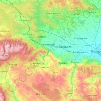
Nom : Carte topographique Pazardzhik, altitude, relief.
Lieu : Pazardzhik, Bulgaria (41.66851 23.75533 42.62901 24.53780)
Altitude moyenne : 931 m
Altitude minimum : 155 m
Altitude maximum : 2 899 m
The northern parts of the region include the middle ridges of the Sredna Gora mountain, to the south the relief flattens and forms the westernmost parts of the Upper Thracian Plain and to the south are located the Rhodope Mountains where most of the forests are situated. The highest point of the region is Savov Vrah at an altitude of 2,306 m while the lowest altitude is around 200 m in the plains of the central area. The climate is transcontinental with milder winter than northern Bulgaria in the lowlands but with very low temperatures and high snowfall in the mountain areas. The average annual temperature is 11.3 °C.
Autres cartes topographiques
Cliquez sur une carte pour visualiser sa topographie, son altitude et son relief.
River Park
Bulgaria > Sofia-City > Vitosha
River Park, Vitosha, Sofia City, Sofia-City, Bulgaria
Altitude moyenne : 746 m
Graf Ignatievo
Graf Ignatievo, Maritsa, Plovdiv, 4198, Bulgaria
Altitude moyenne : 191 m
Драгойна
Bulgaria > Plovdiv > Dragoynovo
Драгойна, Dragoynovo, Parvomai, Plovdiv, 4293, Bulgaria
Altitude moyenne : 534 m
Panichishte
Panichishte, Sapareva Bania, Kyustendil, 2650, Bulgaria
Altitude moyenne : 1 326 m