
Carte topographique Rupandehi
Carte interactive
Cliquez sur la carte pour afficher l’altitude.
À propos de cette carte
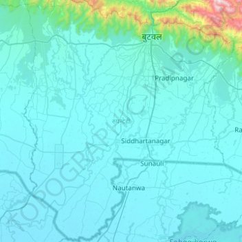
Nom : Carte topographique Rupandehi, altitude, relief.
Lieu : Rupandehi, Lumbini Provicne, Nepal (27.33016 83.20425 27.76729 83.63440)
Altitude moyenne : 182 m
Altitude minimum : 86 m
Altitude maximum : 1 800 m
The district lies on the southern and western part of Nepal. On the East it shares border with Nawalparasi District, on West with Kapilvastu District, on North with Palpa District and on South with India. The elevation of the district lies between 100m to 1229m from sea level. The total area of the district is 1,360 km² with 16.1% in Churia Range and rest in the Terai region.
Autres cartes topographiques
Cliquez sur une carte pour visualiser sa topographie, son altitude et son relief.
Majhakot
Nepal > Gandaki Province > Syangja
Majhakot, Waling-03, Waling, Syangja, Gandaki Province, Nepal
Altitude moyenne : 1 178 m
Namche Bazaar
Nepal > Koshi Province > Solukhumbu
Namche Bazaar, Khumbupasanglahmu, Solukhumbu, Koshi Province, 56002, Nepal
Altitude moyenne : 3 526 m
Phaktanglung
Nepal > Koshi Province > Taplejung
Phaktanglung, Taplejung, Koshi Province, Nepal
Altitude moyenne : 4 548 m
Naar
Nepal > Gandaki Province > Manang
Naar, Narphu, Manang, Gandaki Province, Nepal
Altitude moyenne : 4 353 m
Musikot
Nepal > Karnali Province > Western Rukum District
Musikot, Western Rukum District, Karnali Province, 22000, Nepal
Altitude moyenne : 1 742 m
Mount Everest
Nepal > Koshi Province > Solukhumbu
Mount Everest, Khumbupasanglahmu, Solukhumbu, Koshi Province, Nepal
Altitude moyenne : 7 850 m
Khumjung
Khumjung, Khumbupasanglahmu, Solukhumbu, Koshi Province, 56002, Nepal
Altitude moyenne : 3 888 m
Himalayas
Nepal > Koshi Province > Solukhumbu
Himalayas, Khumbupasanglahmu, Solukhumbu, Koshi Province, Nepal
Altitude moyenne : 7 555 m
Kangchenjunga
Kangchenjunga, Lelep, Phaktanglung, Taplejung, Koshi Province, Nepal
Altitude moyenne : 7 724 m
Bhotang
Nepal > Sindhupalchowk > Motang
Bhotang, Motang, Panchpokhari Thangpal, Sindhupalchowk, Bagmati Pradesh, Nepal
Altitude moyenne : 1 792 m
Mount Everest
Nepal > Eastern Development Region > Tashi Dzom > Khumjung
Mount Everest, Khumjung, Solukhumbu, Sagarmatha, Eastern Development Region, Nepal
Altitude moyenne : 7 841 m
Far-Western Development Region
Far-Western Development Region, Sudurpashchim Pradesh, Nepal
Altitude moyenne : 1 858 m
Lukla
Lukla, Chaurikharka, Khumbupasanglahmu, Solukhumbu, Province #1, Nepal
Altitude moyenne : 2 996 m
Kathmandu
Nepal > Bagmati Province > Kathmandu
Kathmandu, Kathmandu Metropolitan City, Kathmandu, Bagmati Province, 46000, Nepal
Altitude moyenne : 1 538 m
Naike Peak
Naike Peak, Samagau, Chum Nubri, Gorkha, Gandaki Pradesh, Nepal
Altitude moyenne : 5 373 m
Mount Lhotse
Nepal > Solukhumbu > Khumjung
Mount Lhotse, Khumjung, Khumbupasanglahmu, Solukhumbu, Province #1, Nepal
Altitude moyenne : 7 375 m
Kali River
Kali River, Pokhara Metropolitan Ward No. 16, Pokhara, Kaski, Gandaki Pradesh, 60600, Nepal
Altitude moyenne : 983 m
Asmit’s Palace
Nepal > Eastern Development Region > Dharan Sub-Metropolitan
Asmit’s Palace, Bhanu Marg, Dhruba Jyori Chowk, Dharan, Dharan Sub-Metropolitan, Sunsari, Koshi, Eastern Development Region, 56100, Nepal
Altitude moyenne : 380 m
Lobuche
Nepal > Eastern Development Region > Khumjung
Lobuche, Khumjung, Solukhumbu, Sagarmatha, Eastern Development Region, 4, Nepal
Altitude moyenne : 4 825 m