
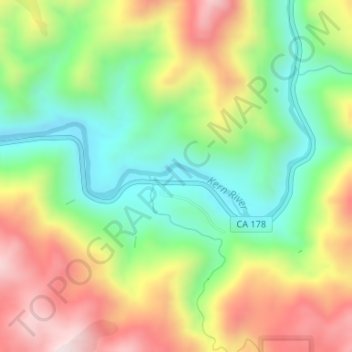
Carte topographique Upper Richbar Picnic Area
Carte interactive
Cliquez sur la carte pour afficher l’altitude.
À propos de cette carte
Nom : Carte topographique Upper Richbar Picnic Area, altitude, relief.
Altitude moyenne : 658 m
Altitude minimum : 425 m
Altitude maximum : 962 m
Autres cartes topographiques
Cliquez sur une carte pour visualiser sa topographie, son altitude et son relief.
Wasco
United States > California > Kern County
Wasco, Kern County, California, United States
Altitude moyenne : 101 m
Mojave
United States > California > Kern County
Mojave, Kern County, California, United States
Altitude moyenne : 857 m
Inyokern
United States > California > Kern County
Inyokern, Kern County, California, United States
Altitude moyenne : 749 m
Baker
United States > California > Kern County > Boron
Baker, Boron, Kern County, California, United States
Altitude moyenne : 765 m
Rosedale
United States > California > Kern County
Rosedale, Kern County, CAL Fire Contract Counties, California, United States
Altitude moyenne : 107 m
Ridgecrest
United States > California > Kern County
Ridgecrest, Kern County, California, 93555, United States
Altitude moyenne : 740 m
Lake Isabella
United States > California > Kern County
Lake Isabella, Kern County, California, United States
Altitude moyenne : 979 m
Boron
United States > California > Kern County > Boron
Boron, Kern County, California, United States
Altitude moyenne : 753 m
Tehachapi
United States > California > Kern County
Tehachapi, Kern County, California, 93561, United States
Altitude moyenne : 1 414 m
Cameron
United States > California > Kern County
Cameron, Kern County, California, United States
Altitude moyenne : 1 309 m
Rio Bravo
United States > California > Kern County
Rio Bravo, Kern County, California, United States
Altitude moyenne : 97 m
Bakersfield
United States > California > Kern County
Bakersfield, Kern County, California, United States
Altitude moyenne : 157 m