
Carte topographique Tehachapi
Carte interactive
Cliquez sur la carte pour afficher l’altitude.
À propos de cette carte
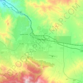
Nom : Carte topographique Tehachapi, altitude, relief.
Lieu : Tehachapi, Kern County, California, 93561, United States (35.09828 -118.59307 35.15843 -118.39649)
Altitude moyenne : 1 414 m
Altitude minimum : 853 m
Altitude maximum : 2 403 m
Tehachapi (/təˈhætʃəpi/ (listen); Kawaiisu: Tihachipia, meaning "hard climb") is a city in Kern County, California, United States, in the Tehachapi Mountains, at an elevation of 3,970 feet (1,210 m), between the San Joaquin Valley and the Mojave Desert. Tehachapi is 35 miles (56 km) east-southeast of Bakersfield, and 20 miles (32 km) west of Mojave. According to the United States Census Bureau, the city has a total area of 10 square miles (26 km2) and a population of 14,414. The Tehachapi area is known for the nearby Tehachapi Loop (a popular railfan site), the Pacific Crest Trail and for the excellent conditions for the aerial sport of gliding.
Autres cartes topographiques
Cliquez sur une carte pour visualiser sa topographie, son altitude et son relief.
Rosedale
United States > California > Kern County
Rosedale, Kern County, California, United States
Altitude moyenne : 113 m
Upper Richbar Picnic Area
United States > California > Kern County
Upper Richbar Picnic Area, Kern County, California, United States
Altitude moyenne : 658 m
Wasco
United States > California > Kern County
Wasco, Kern County, California, United States
Altitude moyenne : 101 m
Mojave
United States > California > Kern County
Mojave, Kern County, California, United States
Altitude moyenne : 857 m
Inyokern
United States > California > Kern County
Inyokern, Kern County, California, United States
Altitude moyenne : 749 m
Baker
United States > California > Kern County > Boron
Baker, Boron, Kern County, California, United States
Altitude moyenne : 765 m
Rosedale
United States > California > Kern County
Rosedale, Kern County, CAL Fire Contract Counties, California, United States
Altitude moyenne : 107 m
Ridgecrest
United States > California > Kern County
Ridgecrest, Kern County, California, 93555, United States
Altitude moyenne : 740 m
Lake Isabella
United States > California > Kern County
Lake Isabella, Kern County, California, United States
Altitude moyenne : 979 m
Boron
United States > California > Kern County > Boron
Boron, Kern County, California, United States
Altitude moyenne : 753 m
Cameron
United States > California > Kern County
Cameron, Kern County, California, United States
Altitude moyenne : 1 309 m
Rio Bravo
United States > California > Kern County
Rio Bravo, Kern County, California, United States
Altitude moyenne : 97 m
Bakersfield
United States > California > Kern County
Bakersfield, Kern County, California, United States
Altitude moyenne : 157 m