
Carte topographique Inyokern
Carte interactive
Cliquez sur la carte pour afficher l’altitude.
À propos de cette carte
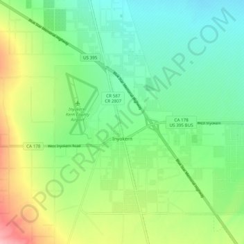
Nom : Carte topographique Inyokern, altitude, relief.
Lieu : Inyokern, Kern County, California, United States (35.62268 -117.87212 35.68164 -117.77582)
Altitude moyenne : 749 m
Altitude minimum : 703 m
Altitude maximum : 842 m
Inyokern (formerly Siding 16 and Magnolia) is a census-designated place (CDP) in Kern County, California, United States. Its name derives from its location near the border between Inyo and Kern Counties. Inyokern is located 8 miles (13 km) west of Ridgecrest, at an elevation of 2,434 feet (742 m). It is on the western side of the Indian Wells Valley. The population was 988 in the 2020 census, down from 1,099 in the 2010 census. It was a railroad town established along the Southern Pacific railroad's Lone Pine Branch (now removed) and with WWII became site of the Naval Air Weapons Station China Lake.
Autres cartes topographiques
Cliquez sur une carte pour visualiser sa topographie, son altitude et son relief.
Rosedale
United States > California > Kern County
Rosedale, Kern County, California, United States
Altitude moyenne : 113 m
Upper Richbar Picnic Area
United States > California > Kern County
Upper Richbar Picnic Area, Kern County, California, United States
Altitude moyenne : 658 m
Wasco
United States > California > Kern County
Wasco, Kern County, California, United States
Altitude moyenne : 101 m
Mojave
United States > California > Kern County
Mojave, Kern County, California, United States
Altitude moyenne : 857 m
Baker
United States > California > Kern County > Boron
Baker, Boron, Kern County, California, United States
Altitude moyenne : 765 m
Rosedale
United States > California > Kern County
Rosedale, Kern County, CAL Fire Contract Counties, California, United States
Altitude moyenne : 107 m
Ridgecrest
United States > California > Kern County
Ridgecrest, Kern County, California, 93555, United States
Altitude moyenne : 740 m
Lake Isabella
United States > California > Kern County
Lake Isabella, Kern County, California, United States
Altitude moyenne : 979 m
Boron
United States > California > Kern County > Boron
Boron, Kern County, California, United States
Altitude moyenne : 753 m
Tehachapi
United States > California > Kern County
Tehachapi, Kern County, California, 93561, United States
Altitude moyenne : 1 414 m
Cameron
United States > California > Kern County
Cameron, Kern County, California, United States
Altitude moyenne : 1 309 m
Rio Bravo
United States > California > Kern County
Rio Bravo, Kern County, California, United States
Altitude moyenne : 97 m
Bakersfield
United States > California > Kern County
Bakersfield, Kern County, California, United States
Altitude moyenne : 157 m