
Carte topographique Clark County
Carte interactive
Cliquez sur la carte pour afficher l’altitude.
À propos de cette carte
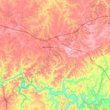
Nom : Carte topographique Clark County, altitude, relief.
Lieu : Clark County, Kentucky, 40391, United States (37.82181 -84.34897 38.11516 -83.96650)
Altitude moyenne : 273 m
Altitude minimum : 171 m
Altitude maximum : 341 m
According to the United States Census Bureau, the county has a total area of 255 square miles (660 km2), of which 252 square miles (650 km2) is land and 2.7 square miles (7.0 km2) (1.1%) is water. The topography of the county is gently rolling. Tobacco is a major farm crop, and livestock are also raised there. Water sources include the Kentucky River, Red River, Lulbegrud Creek, and Boone's Creek. Lulbegrud Creek is named for Lorbrulgrud, the capital city of Brobdingnag, the land of giant people in Jonathan Swift's Gulliver's Travels.
Autres cartes topographiques
Cliquez sur une carte pour visualiser sa topographie, son altitude et son relief.
Lexington
United States > Kentucky > Lexington
Lexington, Fayette County, Kentucky, 40508, United States
Altitude moyenne : 285 m
East Bernstadt
United States > Kentucky > Laurel County
East Bernstadt, Laurel County, Kentucky, United States
Altitude moyenne : 367 m
Sandhill
United States > Kentucky > Muhlenberg County
Sandhill, Muhlenberg County, Kentucky, 42369, United States
Altitude moyenne : 143 m
McDowell
United States > Kentucky > Floyd County
McDowell, Floyd County, Kentucky, 41647, United States
Altitude moyenne : 324 m
Indian Hills Cherokee Section
United States > Kentucky > Jefferson County > Indian Hills
Indian Hills Cherokee Section, Indian Hills, Jefferson County, Kentucky, 40207, United States
Altitude moyenne : 168 m
Morning View
United States > Kentucky > Kenton County
Morning View, Kenton County, Kentucky, 41063, United States
Altitude moyenne : 192 m
Broad Bottom
United States > Kentucky > Pike County
Broad Bottom, Pike County, Kentucky, 41659, United States
Altitude moyenne : 274 m
Louisville
United States > Kentucky > Jefferson County > Louisville
Louisville, Jefferson County, Kentucky, 40202-2923, United States
Altitude moyenne : 180 m
Plumville
United States > Kentucky > Mason County
Plumville, Mason County, Kentucky, United States
Altitude moyenne : 247 m
Lawrence County
Lawrence County, Kentucky, United States
Altitude moyenne : 255 m
Carrollton
United States > Kentucky > Carroll County
Carrollton, Carroll County, Kentucky, United States
Altitude moyenne : 170 m
Livingston County
Livingston County, Kentucky, United States
Altitude moyenne : 131 m
Keaton
United States > Kentucky > Johnson County
Keaton, Johnson County, Kentucky, 41226, United States
Altitude moyenne : 270 m
Owensboro
United States > Kentucky > Daviess County
Owensboro, Daviess County, Kentucky, United States
Altitude moyenne : 123 m
Aboretum
United States > Kentucky > Calloway County > Murray
Aboretum, Murray, Calloway County, Kentucky, United States
Altitude moyenne : 168 m
Edsel
United States > Kentucky > Elliott County
Edsel, Elliott County, Kentucky, United States
Altitude moyenne : 277 m
Dunmor
United States > Kentucky > Muhlenberg County
Dunmor, Muhlenberg County, Kentucky, 42339, United States
Altitude moyenne : 179 m
Villa Hills
United States > Kentucky > Kenton County
Villa Hills, Kenton County, Kentucky, United States
Altitude moyenne : 224 m
Oak Grove
United States > Kentucky > Christian County
Oak Grove, Christian County, Kentucky, 42262, United States
Altitude moyenne : 170 m
Muhlenberg County
Muhlenberg County, Kentucky, United States
Altitude moyenne : 144 m
Burtonville
United States > Kentucky > Lewis County
Burtonville, Lewis County, Kentucky, United States
Altitude moyenne : 254 m
Buster Hill
United States > Kentucky > Wayne County > Monticello
Buster Hill, Monticello, Wayne County, Kentucky, 42633, United States
Altitude moyenne : 295 m
Limp
United States > Kentucky > Hardin County
Limp, Hardin County, Kentucky, United States
Altitude moyenne : 211 m
Danville
United States > Kentucky > Boyle County
Danville, Boyle County, Kentucky, United States
Altitude moyenne : 290 m
Elizabethtown
United States > Kentucky > Hardin County
Elizabethtown, Hardin County, Kentucky, 42701, United States
Altitude moyenne : 241 m
Hindman
United States > Kentucky > Knott County
Hindman, Knott County, Kentucky, United States
Altitude moyenne : 388 m
E.P. "Tom" Sawyer State Park
United States > Kentucky > Jefferson County > Louisville > Lakeland
E.P. "Tom" Sawyer State Park, Lakeland, Louisville, Jefferson County, Kentucky, United States
Altitude moyenne : 209 m
Lebanon Junction
United States > Kentucky > Bullitt County
Lebanon Junction, Bullitt County, Kentucky, United States
Altitude moyenne : 144 m
Gilbertsville
United States > Kentucky > Marshall County
Gilbertsville, Marshall County, Kentucky, United States
Altitude moyenne : 104 m
Morehead
United States > Kentucky > Rowan County
Morehead, Rowan County, Kentucky, 40351, United States
Altitude moyenne : 287 m
McConnell Springs
United States > Kentucky > Fayette County > Lexington
McConnell Springs, Lexington, Fayette County, Kentucky, United States
Altitude moyenne : 287 m
Guthrie
United States > Kentucky > Todd County
Guthrie, Todd County, Kentucky, United States
Altitude moyenne : 172 m
Maysville
United States > Kentucky > Mason County
Maysville, Mason County, Kentucky, 41056, United States
Altitude moyenne : 236 m
Wilmore
United States > Kentucky > Jessamine County
Wilmore, Jessamine County, Kentucky, 40390, United States
Altitude moyenne : 272 m
Dry Ridge
United States > Kentucky > Grant County
Dry Ridge, Grant County, Kentucky, United States
Altitude moyenne : 274 m
Epperson
United States > Kentucky > McCracken County
Epperson, McCracken County, Kentucky, United States
Altitude moyenne : 107 m
Hampton Manor
United States > Kentucky > Clark County > Winchester
Hampton Manor, Winchester, Clark County, Kentucky, 40391, United States
Altitude moyenne : 297 m
Nicholasville
United States > Kentucky > Jessamine County
Nicholasville, Jessamine County, Kentucky, 40356, United States
Altitude moyenne : 285 m
Eolia
United States > Kentucky > Letcher County
Eolia, Letcher County, Kentucky, 40826, United States
Altitude moyenne : 612 m
William Whitley State Historic House
United States > Kentucky > Lincoln County
William Whitley State Historic House, Lincoln County, Kentucky, United States
Altitude moyenne : 284 m
Crestwood
United States > Kentucky > Oldham County
Crestwood, Oldham County, Kentucky, United States
Altitude moyenne : 223 m
West Point
United States > Kentucky > Hardin County
West Point, Hardin County, Kentucky, United States
Altitude moyenne : 163 m
Taylor Mill
United States > Kentucky > Kenton County
Taylor Mill, Kenton County, Kentucky, 41015, United States
Altitude moyenne : 211 m
Shakertown
United States > Kentucky > Mercer County
Shakertown, Mercer County, Kentucky, United States
Altitude moyenne : 252 m
Weeksbury
United States > Kentucky > Floyd County
Weeksbury, Floyd County, Kentucky, 41669, United States
Altitude moyenne : 487 m