
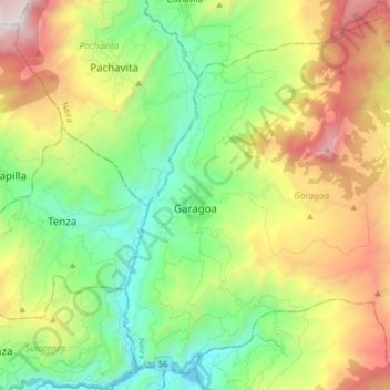
Carte topographique Garagoa
Carte interactive
Cliquez sur la carte pour afficher l’altitude.
À propos de cette carte
Nom : Carte topographique Garagoa, altitude, relief.
Altitude moyenne : 1 988 m
Altitude minimum : 1 245 m
Altitude maximum : 3 275 m
Garagoa (Spanish pronunciation: [ɡaɾaˈɣoa]) is a town and municipality in Colombia, located in the Boyacá Department. It covers an area of 191.75 km2 and the urban centre is located at an altitude of 1,650 metres (5,410 ft) above sea level. Parts of the municipality reach altitudes of 3,050 metres (10,010 ft). It is the capital of the province of Neira. It is also the seat of the Diocese of Garagoa of the Catholic Church. The municipality is situated in the Eastern Ranges of the Colombian Andes and borders Chinavita in the north, Macanal in the south, Tenza and Sutatenza in the west and Miraflores and Chinavita in the east.
Autres cartes topographiques
Cliquez sur une carte pour visualiser sa topographie, son altitude et son relief.
Cordillera Oriental
Cordillera Oriental, Güicán, Gutiérrez, Boyacá, Colombia
Altitude moyenne : 4 825 m
Villa de Leiva
Colombia > Boyacá > Villa de Leyva > Villa de Leiva
Villa de Leiva, Villa de Leyva, Ricaurte, Boyacá, Colombia
Altitude moyenne : 2 175 m
Miraflores
Colombia > Boyacá > Miraflores
Miraflores, Lengupá, Boyacá, Colombia
Altitude moyenne : 1 943 m
Villa de Leyva
Villa de Leyva, Ricaurte, Boyacá, RAP (Especial) Central, Colombia
Altitude moyenne : 2 416 m
Ventaquemada
Colombia > Boyacá > Ventaquemada > Ventaquemada
Ventaquemada, Márquez, Boyacá, 153640, Colombia
Altitude moyenne : 2 813 m
Villa de Leyva
Colombia > Boyacá > Villa de Leyva
Villa de Leyva, Boyacá, 15401, Colombia
Altitude moyenne : 2 673 m