
Carte topographique Boavita
Carte interactive
Cliquez sur la carte pour afficher l’altitude.
À propos de cette carte
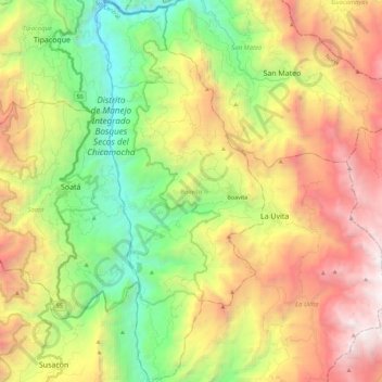
Nom : Carte topographique Boavita, altitude, relief.
Lieu : Boavita, Norte, Boyacá, 151060, Colombia (6.22068 -72.66525 6.44412 -72.56642)
Altitude moyenne : 2 435 m
Altitude minimum : 1 169 m
Altitude maximum : 4 133 m
Boavita is a town and municipality in the Colombian Department of Boyacá, part of the subregion of the Northern Boyacá Province. The urban centre of Boavita is situated in the Eastern Ranges of the Colombian Andes at an altitude of 2,114 metres (6,936 ft) and a distance of 184 kilometres (114 mi) from the department capital Tunja. The municipality borders Capitanejo, Santander, and the Nevado River in the north, San Mateo and La Uvita in the east, Tipacoque and Soatá in the west and Susacón in the south.
Autres cartes topographiques
Cliquez sur une carte pour visualiser sa topographie, son altitude et son relief.
Cordillera Oriental
Cordillera Oriental, Güicán, Gutiérrez, Boyacá, Colombia
Altitude moyenne : 4 825 m
Villa de Leiva
Colombia > Boyacá > Villa de Leyva > Villa de Leiva
Villa de Leiva, Villa de Leyva, Ricaurte, Boyacá, Colombia
Altitude moyenne : 2 175 m
Miraflores
Colombia > Boyacá > Miraflores
Miraflores, Lengupá, Boyacá, Colombia
Altitude moyenne : 1 943 m
Villa de Leyva
Villa de Leyva, Ricaurte, Boyacá, RAP (Especial) Central, Colombia
Altitude moyenne : 2 416 m
Ventaquemada
Colombia > Boyacá > Ventaquemada > Ventaquemada
Ventaquemada, Márquez, Boyacá, 153640, Colombia
Altitude moyenne : 2 813 m
Villa de Leyva
Colombia > Boyacá > Villa de Leyva
Villa de Leyva, Boyacá, 15401, Colombia
Altitude moyenne : 2 673 m