
Carte topographique Duitama
Carte interactive
Cliquez sur la carte pour afficher l’altitude.
À propos de cette carte
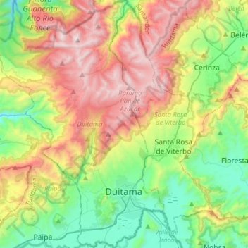
Nom : Carte topographique Duitama, altitude, relief.
Lieu : Duitama, Tundama, Boyacá, RAP (Especial) Central, Colombia (5.77007 -73.17625 6.02490 -72.99248)
Altitude moyenne : 3 019 m
Altitude minimum : 2 374 m
Altitude maximum : 4 036 m
Duitama (Spanish pronunciation: [dwiˈtama]) is a city and municipality in the department of Boyacá. It is the capital of the Tundama Province. Duitama is located 195 kilometres (121 mi) northeast of Bogotá, the capital city of Colombia and 50 kilometres (31 mi) northeast of Tunja, the capital Boyacá. Duitama has existed since pre-Columbian times, when the Muisca inhabited the hills surrounding a former lake in the valley. The original name of Duitama was "Tundama", named after cacique Tundama. The elevation of the city is about 2,590 metres (8,500 ft) above sea level and the average temperature is 16 °C. Duitama is known as "The Pearl of Boyacá".
Autres cartes topographiques
Cliquez sur une carte pour visualiser sa topographie, son altitude et son relief.
Cordillera Oriental
Cordillera Oriental, Güicán, Gutiérrez, Boyacá, Colombia
Altitude moyenne : 4 825 m
Villa de Leiva
Colombia > Boyacá > Villa de Leyva > Villa de Leiva
Villa de Leiva, Villa de Leyva, Ricaurte, Boyacá, Colombia
Altitude moyenne : 2 175 m
Miraflores
Colombia > Boyacá > Miraflores
Miraflores, Lengupá, Boyacá, Colombia
Altitude moyenne : 1 943 m
Villa de Leyva
Villa de Leyva, Ricaurte, Boyacá, RAP (Especial) Central, Colombia
Altitude moyenne : 2 416 m
Ventaquemada
Colombia > Boyacá > Ventaquemada > Ventaquemada
Ventaquemada, Márquez, Boyacá, 153640, Colombia
Altitude moyenne : 2 813 m
Villa de Leyva
Colombia > Boyacá > Villa de Leyva
Villa de Leyva, Boyacá, 15401, Colombia
Altitude moyenne : 2 673 m