
Faire un don
Équipez-vous pour votre prochaine aventure :
En tant que Partenaire Amazon, ce site perçoit une commission sur les achats éligibles sans surcoût pour vous.
Carte topographique Hamburg
Cliquez sur la carte pour afficher l’altitude.
Faire un don
Équipez-vous pour votre prochaine aventure :
En tant que Partenaire Amazon, ce site perçoit une commission sur les achats éligibles sans surcoût pour vous.
Hamburg
The neighborhoods of Neuenfelde, Cranz, Francop and Finkenwerder are part of the Altes Land (old land) region, the largest contiguous fruit-producing region in Central Europe. Neugraben-Fischbek has Hamburg's highest elevation, the Hasselbrack at 116.2 metres (381 ft) AMSL. Hamburg borders the states of Schleswig-Holstein and Lower Saxony.
Faire un don
Équipez-vous pour votre prochaine aventure :
En tant que Partenaire Amazon, ce site perçoit une commission sur les achats éligibles sans surcoût pour vous.
À propos de cette carte
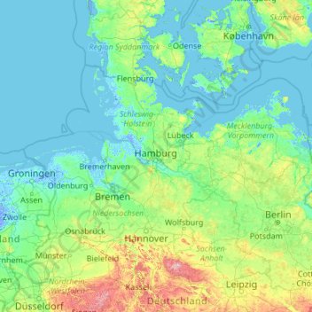
Nom : Carte topographique Hamburg, altitude, relief.
Lieu : Hamburg, Germany (50.94376 7.40991 56.14376 12.60991)
Altitude moyenne : 56 m
Altitude minimum : -5 m
Altitude maximum : 999 m
Faire un don
Équipez-vous pour votre prochaine aventure :
En tant que Partenaire Amazon, ce site perçoit une commission sur les achats éligibles sans surcoût pour vous.
Autres cartes topographiques
Cliquez sur une carte pour visualiser sa topographie, son altitude et son relief.
Munich
Munich lies on the elevated plains of Upper Bavaria, about 50 km (31 mi) north of the northern edge of the Alps, at an altitude of about 520 m (1,706 ft) ASL. The local rivers are the Isar and the Würm. Munich is situated in the Northern Alpine Foreland. The northern part of this sandy plateau includes a…
Altitude moyenne : 524 m
Aachen
Germany > North Rhine-Westphalia > Aachen (district)
The maximum dimensions of the city's territory are 21.6 km (13+3⁄8 mi) from north to south, and 17.2 km (10+3⁄4 mi) from east to west. The city limits are 87.7 km (54+1⁄2 mi) long, of which 23.8 km (14+3⁄4 mi) border Belgium and 21.8 km (13+1⁄2 mi) the Netherlands. The highest point in Aachen,…
Altitude moyenne : 225 m
Nuremberg
Nuremberg has an oceanic climate (Köppen Cfb) with a certain humid continental influence (Dfb), categorized in the latter by the 0 °C isotherm. The city's climate is influenced by its inland position and higher altitude. Winters are changeable, with either mild or cold weather: the average temperature is…
Altitude moyenne : 336 m
Faire un don
Équipez-vous pour votre prochaine aventure :
En tant que Partenaire Amazon, ce site perçoit une commission sur les achats éligibles sans surcoût pour vous.
Baden-Württemberg
The climate across the states varies. This is mostly due to a high amount of mountains and highlands inside of the state. Most parts in the western parts (Baden) lower than 500–800 metres (1,600–2,600 ft) enjoy an almost year round mild oceanic climate (cfb in Köppen classification). The climate in the…
Altitude moyenne : 442 m
Saxony
The Ore Mountains in southern Saxony are traditionally a region of winter sports. The ski ressort of Oberwiesenthal is the highest town of Germany, at an altitude of 900 m, though the surrounding mountains do not reach the same height as in the alpine areas of Southern Germany. Thus, climate change is posing a…
Altitude moyenne : 290 m
Faire un don
Équipez-vous pour votre prochaine aventure :
En tant que Partenaire Amazon, ce site perçoit une commission sur les achats éligibles sans surcoût pour vous.
Hanover
Germany > Lower Saxony > Region Hannover
In 1636 George, Duke of Brunswick-Lüneburg, ruler of the Brunswick-Lüneburg principality of Calenberg, moved his residence to Hanover. The Dukes of Brunswick-Lüneburg were elevated by the Holy Roman Emperor to the rank of Prince-Elector in 1692 and this elevation was confirmed by the Imperial Diet in 1708.…
Altitude moyenne : 61 m
Hamburg
The neighborhoods of Neuenfelde, Cranz, Francop and Finkenwerder are part of the Altes Land (old land) region, the largest contiguous fruit-producing region in Central Europe. Neugraben-Fischbek has Hamburg's highest elevation, the Hasselbrack at 116.2 metres (381 ft) AMSL. Hamburg borders the states of…
Altitude moyenne : 27 m
Black Forest
Its highest peak is the Feldberg with an elevation of 1,493 metres (4,898 ft) above sea level. Roughly oblong in shape, with a length of 160 kilometres (100 miles) and breadth of up to 50 km (30 mi), it has an area of about 6,009 km2 (2,320 sq mi).
Altitude moyenne : 471 m
Faire un don
Équipez-vous pour votre prochaine aventure :
En tant que Partenaire Amazon, ce site perçoit une commission sur les achats éligibles sans surcoût pour vous.
Essen
Germany > North Rhine-Westphalia
The lowest point can be found in the northern borough of Karnap at 26.5 m (86.9 ft), the highest point in the borough of Heidhausen at 202.5 m (664 ft). The average elevation is 116 m (381 ft).
Altitude moyenne : 86 m
Munich
Munich lies on the elevated plains of Upper Bavaria, about 50 km (31 mi) north of the northern edge of the Alps, at an altitude of about 520 m (1,706 ft) ASL. The local rivers are the Isar and the Würm. Munich is situated in the Northern Alpine Foreland. The northern part of this sandy plateau includes a…
Altitude moyenne : 524 m
Faire un don
Équipez-vous pour votre prochaine aventure :
En tant que Partenaire Amazon, ce site perçoit une commission sur les achats éligibles sans surcoût pour vous.
Nürburg
Germany > Rhineland-Palatinate > Landkreis Ahrweiler
Nürburg has a semi-continental climate with both oceanic and continental tendencies. It does however land in the former category (Köppen Cfb). With regards to the racetrack, due to the Nordschleife's varied terrain and elevation, weather may be completely different on either end of the track. The elevation…
Altitude moyenne : 560 m
Faire un don
Équipez-vous pour votre prochaine aventure :
En tant que Partenaire Amazon, ce site perçoit une commission sur les achats éligibles sans surcoût pour vous.
Faire un don
Équipez-vous pour votre prochaine aventure :
En tant que Partenaire Amazon, ce site perçoit une commission sur les achats éligibles sans surcoût pour vous.
Berlin
Berlin straddles the banks of the Spree, which flows into the Havel (a tributary of the Elbe) in the western borough of Spandau. Among the city's main topographical features are the many lakes in the western and southeastern boroughs formed by the Spree, Havel and Dahme, the largest of which is Lake…
Altitude moyenne : 48 m
Elbe
The Elbe (Labe) rises on the slopes of Mt. Violík at an elevation of 1,386 metres (4,547 ft) in the Giant Mountains on the northwest borders of the Czech Republic. Of the numerous small streams whose waters compose the infant river. After plunging down the 30 metres (98 ft) of the Elbe Falls, the latter…
Altitude moyenne : 179 m
Faire un don
Équipez-vous pour votre prochaine aventure :
En tant que Partenaire Amazon, ce site perçoit une commission sur les achats éligibles sans surcoût pour vous.
Faire un don
Équipez-vous pour votre prochaine aventure :
En tant que Partenaire Amazon, ce site perçoit une commission sur les achats éligibles sans surcoût pour vous.
Berlin
Berlin straddles the banks of the Spree, which flows into the Havel (a tributary of the Elbe) in the western borough of Spandau. Among the city's main topographical features are the many lakes in the western and southeastern boroughs formed by the Spree, Havel and Dahme, the largest of which is Lake…
Altitude moyenne : 48 m
Ilmenau
Germany > Thuringia > Ilm-Kreis
Ilmenau (German pronunciation: [ˈɪlmənaʊ] ) is a town in Thuringia, central Germany. It is the largest town within the Ilm district with a population of 38,600, while the district capital is Arnstadt. Ilmenau is located approximately 33 km (21 miles) south of Erfurt and 135 km (84 miles) north of Nuremberg…
Altitude moyenne : 604 m
Garbsen
Germany > Lower Saxony > Region Hannover
Garbsen belongs to the Weser-Aller-Flachland natural area and is situated between the lowlands of the river Leine and the Otternhagener Moor. The differences in altitude are only a few metres.
Altitude moyenne : 50 m
Stuttgart
Stuttgart covers an area of 207.35 km2 (80 sq mi) and sits at elevation ranging from 207 m (679 ft) above sea level by the Neckar river to 549 m (1,801 ft) on Bernhartshöhe hill – something rather unique in large German cities. The most prominent elevated locales in Stuttgart are the Birkenkopf (511 m…
Altitude moyenne : 351 m
Faire un don
Équipez-vous pour votre prochaine aventure :
En tant que Partenaire Amazon, ce site perçoit une commission sur les achats éligibles sans surcoût pour vous.
Ore Mountains
The higher altitudes from around 500 m above sea level on the German side belong to the Ore Mountains/Vogtland Nature Park – the largest of its kind in Germany with a length of 120 km. The eastern Ore Mountains are protected landscape. Other smaller areas on the German and Czech sides are protected as nature…
Altitude moyenne : 443 m
Hopfensee-Achen
Germany > Bavaria > Landkreis Ostallgäu > Füssen > Hopfen am See
Altitude moyenne : 809 m
Mainz
Germany > Rhineland-Palatinate
Nevertheless, the post-war reconstruction took place very slowly. While cities such as Frankfurt had been rebuilt fast by a central authority, only individual efforts were initially successful in rebuilding Mainz. The reason for this was that the French wanted Mainz to expand and become a model city. Mainz lay…
Altitude moyenne : 132 m
Faire un don
Équipez-vous pour votre prochaine aventure :
En tant que Partenaire Amazon, ce site perçoit une commission sur les achats éligibles sans surcoût pour vous.
Karlsruhe
The city lies at an altitude between 100 and 322 m (near the communications tower in the suburb of Grünwettersbach). Its geographical coordinates are 49°00′N 8°24′E / 49.000°N 8.400°E / 49.000; 8.400; the 49th parallel runs through the city centre, which puts it at the same latitude as much…
Altitude moyenne : 132 m
Hesse
Oculus Optikgeräte manufactures Scheimpflug tomographs for examining the anterior segment of the eye, topographers for measuring the anterior surface of the cornea, tonometers for assessing the biomechanical properties of the cornea, a wide-angle observation system for vitreous body surgery, universal trial…
Altitude moyenne : 313 m
Faire un don
Équipez-vous pour votre prochaine aventure :
En tant que Partenaire Amazon, ce site perçoit une commission sur les achats éligibles sans surcoût pour vous.
Harz
The Harz (German: [haːɐ̯ts] (listen)) is a highland area in northern Germany. It has the highest elevations for that region, and its rugged terrain extends across parts of Lower Saxony, Saxony-Anhalt, and Thuringia. The name Harz derives from the Middle High German word Hardt or Hart (hill forest). The name…
Altitude moyenne : 280 m
Bad Hersfeld
Germany > Hesse > Landkreis Hersfeld-Rotenburg
The Flugplatz Johannesberg has the status of Special Airfield. The runway, some 671 m long and 18 m wide, is paved with asphalt and oriented in a north–south direction. The airfield lies on the Johannesberg in the like-named outlying centre at an elevation of 284 m above sea level.
Altitude moyenne : 305 m
Faire un don
Équipez-vous pour votre prochaine aventure :
En tant que Partenaire Amazon, ce site perçoit une commission sur les achats éligibles sans surcoût pour vous.
Schleswig-Holstein
The Baltic Sea coast in the east of Schleswig-Holstein is marked by bays, fjords, and cliff lines. Rolling hills (the highest elevation is the Bungsberg at 168 metres or 551 feet) and many lakes are found, especially in the eastern part of Holstein called the Holstein Switzerland and the former Duchy of…
Altitude moyenne : 17 m
Garmisch-Partenkirchen
Germany > Bavaria > Landkreis Garmisch-Partenkirchen
Garmisch-Partenkirchen leans towards an oceanic climate, and its winters are colder than the rest of Bavaria. Due to its higher elevation, it is very close to the winters associated with continental climates; it has a relatively wet and snowy climate, with high precipitation year-round.
Altitude moyenne : 1 326 m
Faire un don
Équipez-vous pour votre prochaine aventure :
En tant que Partenaire Amazon, ce site perçoit une commission sur les achats éligibles sans surcoût pour vous.
Wiesbaden
The highest point of the Wiesbaden municipality is located northwest of the city center near the summit of the Hohe Wurzel, with an elevation of 608 metres (1,995 ft) above sea level. The lowest point is the harbour entrance of Schierstein at 83 metres (272 ft) above sea level. The central square (the…
Altitude moyenne : 221 m
Faire un don
Équipez-vous pour votre prochaine aventure :
En tant que Partenaire Amazon, ce site perçoit une commission sur les achats éligibles sans surcoût pour vous.
Faire un don
Équipez-vous pour votre prochaine aventure :
En tant que Partenaire Amazon, ce site perçoit une commission sur les achats éligibles sans surcoût pour vous.
Ulm
Ulm lies at the point where the rivers Blau and Iller join the Danube, at an altitude of 479 m (1,571.52 ft) above sea level. Most parts of the city, including the old town, are situated on the northern bank of the Danube; only the districts of Wiblingen, Gögglingen, Donaustetten and Unterweiler lie on the…
Altitude moyenne : 518 m
Faire un don
Équipez-vous pour votre prochaine aventure :
En tant que Partenaire Amazon, ce site perçoit une commission sur les achats éligibles sans surcoût pour vous.
Ramstein-Miesenbach
Germany > Rhineland-Palatinate > Landkreis Kaiserslautern
Altitude moyenne : 266 m
5er-Grube
Germany > Bavaria > Landkreis Starnberg > Krailling > Kraillinger Innovations Meile KIM
Altitude moyenne : 562 m
Faire un don
Équipez-vous pour votre prochaine aventure :
En tant que Partenaire Amazon, ce site perçoit une commission sur les achats éligibles sans surcoût pour vous.
Faire un don
Équipez-vous pour votre prochaine aventure :
En tant que Partenaire Amazon, ce site perçoit une commission sur les achats éligibles sans surcoût pour vous.
Schliersee
Germany > Bavaria > Landkreis Miesbach
Schliersee is located on the northeastern shore of the lake of the same name and is a well known resort in the Bavarian Alps. Schliersee provides scenic views of the surrounding mountains, in particular Aiplspitz, Jägerkamp (German), Brecherspitz and Bodenschneid, all belonging to the Mangfallgebirge range.…
Altitude moyenne : 1 079 m
Sinsheim-Steinsfurt / Insenbach
Germany > Baden-Württemberg > Rhein-Neckar-Kreis > Sinsheim
Altitude moyenne : 204 m
Faire un don
Équipez-vous pour votre prochaine aventure :
En tant que Partenaire Amazon, ce site perçoit une commission sur les achats éligibles sans surcoût pour vous.
Eltz Castle
Germany > Rhineland-Palatinate > Landkreis Mayen-Koblenz > Wierschem
Altitude moyenne : 219 m
Faire un don
Équipez-vous pour votre prochaine aventure :
En tant que Partenaire Amazon, ce site perçoit une commission sur les achats éligibles sans surcoût pour vous.
Winterberg
Germany > North Rhine-Westphalia > Hochsauerlandkreis
Winterberg experiences a humid continental climate (Köppen Dfb) like most of Germany, however also bordering on subarctic climate (Dfc), thanks to its altitude, with only having one average temperature above 10 °C and September only being barely above it. The summers are short and cool, while the winters are…
Altitude moyenne : 628 m
Faire un don
Équipez-vous pour votre prochaine aventure :
En tant que Partenaire Amazon, ce site perçoit une commission sur les achats éligibles sans surcoût pour vous.
Faire un don
Équipez-vous pour votre prochaine aventure :
En tant que Partenaire Amazon, ce site perçoit une commission sur les achats éligibles sans surcoût pour vous.
Faire un don
Équipez-vous pour votre prochaine aventure :
En tant que Partenaire Amazon, ce site perçoit une commission sur les achats éligibles sans surcoût pour vous.
Ulm
Ulm lies at the point where the rivers Blau and Iller join the Danube, at an altitude of 479 m (1,571.52 ft) above sea level. Most parts of the city, including the old town, are situated on the northern bank of the Danube; only the districts of Wiblingen, Gögglingen, Donaustetten and Unterweiler lie on the…
Altitude moyenne : 518 m
Faire un don
Équipez-vous pour votre prochaine aventure :
En tant que Partenaire Amazon, ce site perçoit une commission sur les achats éligibles sans surcoût pour vous.
Faire un don
Équipez-vous pour votre prochaine aventure :
En tant que Partenaire Amazon, ce site perçoit une commission sur les achats éligibles sans surcoût pour vous.