
Carte topographique Central District
Carte interactive
Cliquez sur la carte pour afficher l’altitude.
À propos de cette carte
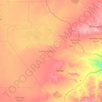
Nom : Carte topographique Central District, altitude, relief.
Lieu : Central District, Botswana (-23.96232 23.88413 -19.00003 29.37389)
Altitude moyenne : 1 006 m
Altitude minimum : 576 m
Altitude maximum : 1 782 m
Most part of Botswana has tableland slopes sliding from east to west. The region has an average elevation of around 915 m (3,002 ft) above the mean sea level. The vegetation type is Savannah, with tall grasses, bushes and trees. The annual precipitation is around 65 cm (26 in), most of which is received during the summer season from November to May. Most of the rivers in the region are seasonal, with Limpopo River, which are prone to flash floods, being the most prominent. There are conflicts between agricultural expansion and protection of indigenous wildlife within the Central District. There are several seasonal rivers in the district including the Boteti River and the Lepashe River, whose flows in the rainy season reach the Makgadikgadi Pans.
Autres cartes topographiques
Cliquez sur une carte pour visualiser sa topographie, son altitude et son relief.
Mabuasehube
Mabuasehube, Kgalagadi District, Botswana
Altitude moyenne : 1 045 m
Lokgwabe
Lokgwabe, Kgalagadi District, Botswana
Altitude moyenne : 1 116 m
Okavango Delta
Botswana > North-West District
Okavango Delta, North-West District, Botswana
Altitude moyenne : 959 m
Boteti River
Boteti River, Central District, Botswana
Altitude moyenne : 914 m
Chobe National Park
Chobe National Park, Chobe District, Botswana
Altitude moyenne : 964 m
Makgadikgadi Pans Game Reserve
Makgadikgadi Pans Game Reserve, Central District, Botswana
Altitude moyenne : 917 m
Gaborone
Botswana > South-East District
Gaborone, South-East District, Botswana
Altitude moyenne : 1 032 m
Jwaneng
Botswana > Southern District > Jwaneng
Jwaneng, Southern District, Botswana
Altitude moyenne : 1 193 m
Selebi Phikwe
Botswana > Central District > Selebi Phikwe
Selebi Phikwe, Central District, Botswana
Altitude moyenne : 863 m
Khwai
Botswana > North-West District > Khwai
Khwai, North-West District, Botswana
Altitude moyenne : 939 m
Kalahari Desert
Kalahari Desert, Ghanzi District, Botswana
Altitude moyenne : 1 168 m
Francistown
Botswana > North-East District > Francistown
Francistown, North-East District, Botswana
Altitude moyenne : 1 007 m
Pandamatenga
Pandamatenga, Chobe District, Botswana
Altitude moyenne : 1 074 m
Gaborone Dam
Botswana > South-East District > Gaborone
Gaborone Dam, Gaborone, South-East District, Botswana
Altitude moyenne : 992 m