
Carte topographique Ghanzi District
Carte interactive
Cliquez sur la carte pour afficher l’altitude.
À propos de cette carte
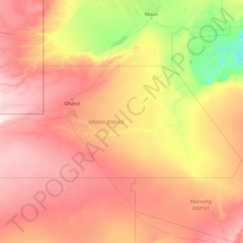
Nom : Carte topographique Ghanzi District, altitude, relief.
Lieu : Ghanzi District, Botswana (-23.32233 19.99908 -20.99537 25.44662)
Altitude moyenne : 1 071 m
Altitude minimum : 902 m
Altitude maximum : 1 391 m
In the west, Ghanzi borders the Omaheke Region of Namibia. Domestically, it borders the following districts: North-West on the north, Central on the east, Kweneng on the southeast, Kgalagadi on the south. Ghanzi is traversed by the northwesterly line of equal latitude and longitude. This region is largely covered by the Kalahari Desert, some of which is also covered by the Makgadikgadi Pans, a large seasonal wetland. The Makgadigadi was one of the Earth's largest lakes during the Pleistocene, but currently provides a vast summer wetland to support tens of thousands of migrating flamingos in the rainy summer season. The largest town in the district is the capital Ghanzi with a population of 21,420 according to the 2011 census, which is fifteen times more than the second-largest village Ncojane has. Most part of Botswana has tableland slopes sliding from east to west. The region has an average elevation of around 550 m (1,800 ft) above the mean sea level. The vegetation type is Savannah, with tall grasses, bushes and trees on the eastern sides, but it is arid in the Central and Western regions. The annual precipitation is around 25 cm (9.8 in), most of which is received during the summer season from November to May. Most of the rivers in the region are seasonal which are prone to flash floods, being the most prominent. The tourist and game reserves in the region are Ghanzi, Central Kalahari Game Reserve, Deception Valley, Ghanzi Craft, Kgalagadi Transfrontier Park, Khutse Game Reserve and Kuru Museum and Cultural Centre.
Autres cartes topographiques
Cliquez sur une carte pour visualiser sa topographie, son altitude et son relief.
Mabuasehube
Mabuasehube, Kgalagadi District, Botswana
Altitude moyenne : 1 045 m
Lokgwabe
Lokgwabe, Kgalagadi District, Botswana
Altitude moyenne : 1 116 m
Okavango Delta
Botswana > North-West District
Okavango Delta, North-West District, Botswana
Altitude moyenne : 959 m
Boteti River
Boteti River, Central District, Botswana
Altitude moyenne : 914 m
Chobe National Park
Chobe National Park, Chobe District, Botswana
Altitude moyenne : 964 m
Makgadikgadi Pans Game Reserve
Makgadikgadi Pans Game Reserve, Central District, Botswana
Altitude moyenne : 917 m
Gaborone
Botswana > South-East District
Gaborone, South-East District, Botswana
Altitude moyenne : 1 032 m
Jwaneng
Botswana > Southern District > Jwaneng
Jwaneng, Southern District, Botswana
Altitude moyenne : 1 193 m
Selebi Phikwe
Botswana > Central District > Selebi Phikwe
Selebi Phikwe, Central District, Botswana
Altitude moyenne : 863 m
Khwai
Botswana > North-West District > Khwai
Khwai, North-West District, Botswana
Altitude moyenne : 939 m
Kalahari Desert
Kalahari Desert, Ghanzi District, Botswana
Altitude moyenne : 1 168 m
Francistown
Botswana > North-East District > Francistown
Francistown, North-East District, Botswana
Altitude moyenne : 1 007 m
Pandamatenga
Pandamatenga, Chobe District, Botswana
Altitude moyenne : 1 074 m
Gaborone Dam
Botswana > South-East District > Gaborone
Gaborone Dam, Gaborone, South-East District, Botswana
Altitude moyenne : 992 m