
Carte topographique River Boyne
Carte interactive
Cliquez sur la carte pour afficher l’altitude.
À propos de cette carte
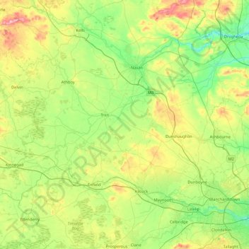
Nom : Carte topographique River Boyne, altitude, relief.
Lieu : River Boyne, Ireland (53.33998 -7.08920 53.73207 -6.23877)
Altitude moyenne : 78 m
Altitude minimum : 0 m
Altitude maximum : 270 m
Autres cartes topographiques
Cliquez sur une carte pour visualiser sa topographie, son altitude et son relief.
Aran Islands
Aran Islands, Conamara Municipal District, County Galway, Connacht, H91 P266, Ireland
Altitude moyenne : 3 m
The Municipal District of Callan — Thomastown
The Municipal District of Callan — Thomastown, County Kilkenny, Leinster, Ireland
Altitude moyenne : 100 m
Raphoe
Raphoe, Lifford-Stranorlar Municipal District, County Donegal, Ireland
Altitude moyenne : 79 m
Ring Hill
Ring Hill, The Municipal District of Thurles, County Tipperary, Munster, Ireland
Altitude moyenne : 315 m
Carrigtwohill
Carrigtwohill, Carrigtohill ED, Municipal District of Cobh, County Cork, Munster, Ireland
Altitude moyenne : 23 m
Oram
Oram, Church Hill ED, Carrickmacross-Castleblaney Municipal District, County Monaghan, Ulster, Ireland
Altitude moyenne : 129 m
Drought
Drought, Kilreekill ED, Loughrea Municipal District, County Galway, Connacht, Ireland
Altitude moyenne : 78 m
Innishannon
Innishannon, Inishannon, The Municipal District of Bandon-Kinsale, County Cork, Munster, Ireland
Altitude moyenne : 54 m
Bruree
Ireland > County Limerick > The Municipal District of Cappamore — Kilmallock
Bruree, The Municipal District of Cappamore — Kilmallock, County Limerick, Munster, Ireland
Altitude moyenne : 62 m
Costelloe
Costelloe, Conamara Municipal District, County Galway, Connacht, H91 A2T6, Ireland
Altitude moyenne : 12 m
Athlone
Athlone, County Westmeath, Leinster, Ireland
Altitude moyenne : 43 m
Kilmichael
Kilmichael, Carrigboy ED, Municipal District of Macroom, County Cork, Munster, P12 W864, Ireland
Altitude moyenne : 133 m
Great Skellig
Great Skellig, Kenmare Municipal District, County Kerry, Munster, Ireland
Altitude moyenne : 1 m
Lismore
Lismore, The Municipal District of Dungarvan — Lismore, County Waterford, Munster, P51 VW44, Ireland
Altitude moyenne : 38 m
Macroom
Macroom, Municipal District of Macroom, County Cork, Munster, Ireland
Altitude moyenne : 110 m
Boston
Boston, Boston ED, West Clare Municipal District, County Clare, Munster, H91 R9FX, Ireland
Altitude moyenne : 25 m
Cashel
Cashel, The Municipal District of Cahir — Cashel, County Tipperary, Munster, Ireland
Altitude moyenne : 115 m
Acres
Acres, Aghavas ED, Ballinamore Municipal District, County Leitrim, Connacht, Ireland
Altitude moyenne : 74 m
Curraghboy
Curraghboy, Rockhill Electoral Division, Athlone Municipal District, County Roscommon, Connacht, N37 EK20, Ireland
Altitude moyenne : 69 m
Furbo
Furbo, County Galway, Connacht, H91 KX27, Ireland
Altitude moyenne : 16 m
Headford
Headford, Headford ED, Tuam Municipal District, County Galway, Connacht, Ireland
Altitude moyenne : 20 m
Curtaun
Curtaun, Beagh ED, Loughrea Municipal District, County Galway, Connacht, Ireland
Altitude moyenne : 27 m
Leamlara
Leamlara, Lisgoold, The Municipal District of East Cork, County Cork, Munster, T56 NH57, Ireland
Altitude moyenne : 145 m
Naas
Naas, The Municipal District of Naas, County Kildare, Leinster, Ireland
Altitude moyenne : 97 m
Killeens
Killeens, Coolhill, The Municipal District of Callan — Thomastown, County Kilkenny, Leinster, Ireland
Altitude moyenne : 63 m
Lecks
Lecks, Shercock ED, Bailieborough-Cootehill Municipal District, County Cavan, Ireland
Altitude moyenne : 128 m
Ballybrack
Ireland > County Dublin > Killiney
Ballybrack, Killiney North DED 1986, Killiney, Dún Laoghaire-Rathdown, County Dublin, Leinster, Ireland
Altitude moyenne : 32 m
Manorhamilton Municipal District
Manorhamilton Municipal District, County Leitrim, Connacht, Ireland
Altitude moyenne : 156 m
Matehy
Matehy, Municipal District of Macroom, County Cork, Munster, Ireland
Altitude moyenne : 107 m
Keshcarrigan
Keshcarrigan, Ballinamore Municipal District, County Leitrim, Connacht, Ireland
Altitude moyenne : 78 m
Kiltegan
Kiltegan, The Municipal District of Baltinglass, County Wicklow, Leinster, Ireland
Altitude moyenne : 150 m
Newmarket
Newmarket, The Municipal District of Kanturk-Mallow, County Cork, Munster, Ireland
Altitude moyenne : 169 m
Killarney
Killarney, Killarney Municipal District, County Kerry, Munster, Ireland
Altitude moyenne : 57 m
Newbridge
Newbridge, The Municipal District of Kildare — Newbridge, County Kildare, Leinster, Ireland
Altitude moyenne : 95 m
Mullyash
Mullyash, Mullyash ED, Carrickmacross-Castleblaney Municipal District, County Monaghan, Ulster, Ireland
Altitude moyenne : 221 m
Watergrasshill
Watergrasshill, Municipal District of Cobh, County Cork, Munster, Ireland
Altitude moyenne : 164 m
Horseleap
Horseleap, The Municipal District of Tullamore, County Offaly, Leinster, Ireland
Altitude moyenne : 70 m
Claremorris-Swinford Municipal District
Claremorris-Swinford Municipal District, County Mayo, Connacht, Ireland
Altitude moyenne : 69 m
Cork City
Ireland > County Cork > Cork
Cork City, Cork, County Cork, Munster, Ireland
Altitude moyenne : 66 m
White River
White River, Dunleer ED, The Municipal District of Ardee, County Louth, Leinster, A92 RP77, Ireland
Altitude moyenne : 75 m
Bellananagh
Bellananagh, Bellananagh ED, Ballyjamesduff Municipal District, County Cavan, H12 K727, Ireland
Altitude moyenne : 94 m
Gurteen
Gurteen, Cappalusk ED, Athenry-Oranmore Municipal District, County Galway, Connacht, Ireland
Altitude moyenne : 89 m
Carrickmines Little
Ireland > County Dublin > Ballyogan
Carrickmines Little, Glencullen Electoral Division, Ballyogan, Dún Laoghaire-Rathdown, County Dublin, Leinster, Ireland
Altitude moyenne : 83 m
Cahir
Cahir, The Municipal District of Cahir — Cashel, County Tipperary, Munster, Ireland
Altitude moyenne : 58 m
Municipal District of Carrigaline
Municipal District of Carrigaline, County Cork, Munster, Ireland
Altitude moyenne : 52 m
Spink
Spink, The Municipal District of Portlaoise, County Laois, Leinster, Ireland
Altitude moyenne : 219 m